| ||||||||||||
| 1 | |||||||||||
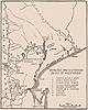
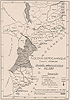
 Magude, in other words, has always been the easiest way for me to talk about the spatial terrain of my research to outsiders who, in one way or another, have had the power to affect my access to the women who inhabit this corner of Mozambique. Fellowship-granting organizations with their own ideas about how Africa may be broken down into investigable units, Mozambican bureaucrats skeptical of my reasons for wanting to venture into the countryside, historians in Mozambique who believe that the country's past must be approached in a "usable" way—all have been interested parties for whom Magude is a convenient construct, necessary in the work of trying to govern, "develop," or study the region. I too employed this convention during the months of preparation and library and archival research prior to my departure for "the field." In Lisbon, Lausanne, Johannesburg, and Maputo, Magude was the shorthand I used for my ultimate destination: the sandy, rolling, sometimes verdant landscape north and west of the elbow in the Nkomati River, the obscure backyard both to southern Mozambique's better-known coastal region and to South Africa's Kruger Park, which abuts this section of the international border. Magude, in other words, has always been the easiest way for me to talk about the spatial terrain of my research to outsiders who, in one way or another, have had the power to affect my access to the women who inhabit this corner of Mozambique. Fellowship-granting organizations with their own ideas about how Africa may be broken down into investigable units, Mozambican bureaucrats skeptical of my reasons for wanting to venture into the countryside, historians in Mozambique who believe that the country's past must be approached in a "usable" way—all have been interested parties for whom Magude is a convenient construct, necessary in the work of trying to govern, "develop," or study the region. I too employed this convention during the months of preparation and library and archival research prior to my departure for "the field." In Lisbon, Lausanne, Johannesburg, and Maputo, Magude was the shorthand I used for my ultimate destination: the sandy, rolling, sometimes verdant landscape north and west of the elbow in the Nkomati River, the obscure backyard both to southern Mozambique's better-known coastal region and to South Africa's Kruger Park, which abuts this section of the international border. | ||||||||||||
Yet stand with your feet anywhere on the ground in Magude district, or on the broken tarmac of the four intersecting paved streets of Magude town, and talk to one woman, then another, about the geography of her life experiences, and you quickly discover that Magude is not a very truthful space-label for Mozambican history when you want to understand that history from women's point of view. In fact, until recently, the notion of Magude as an organizing principle in everyday life was largely irrelevant for many women within the district's formal boundaries. What made this construct a practical reality for most rural dwellers were the physical dislocations of the war and the measures for distributing emergency aid. Among older women during the period of my fieldwork, Magude rarely entered ordinary discourse at all. For these women, with little or no formal schooling, knowledge of Portuguese, or direct exposure to the workings of the colonial or postcolonial state, Magude was a label on someone else's map, and that someone else usually wanted something from them: money or food, information or work, obedience or a more active display of enthusiasm and loyalty. Moreover, among all the women I interviewed, there was not a single one whose life experiences could be contained within the boundaries of Magude district as they are now or as they ever have been defined. Magude, then, does not adequately represent the physical space whose history women's recollections opened to me. 1 Indeed, I know of no single word that could contain all the tangle of histories that, according to women's memories, have made an imprint on the sands of this ancient place. | ||||||||||||
The problem of historical place-naming in southeastern Africa becomes even more acute when we turn to the past beyond women's memories, a past for which records are fragmentary, fugitive, and cryptic about such issues as why people conceptualize the world the way they do. Moreover, in past centuries many different kinds of people have set their feet or fancies on the place now known as Magude and have generated maps that express their own ideas about its spatial definition, its significant features, and the larger political, cultural, or economic unit(s) to which it should belong. Long before Portuguese, British, and Afrikaner colonizers negotiated the territorial limits of administrative control here in the late nineteenth century, Africans of diverse origins and identities traversed, inhabited, and fought over this region. European travelers and traders exchanged rumors of a wealthy kingdom at the Nkomati River bend, and Swiss missionaries in the Transvaal imagined extending their influence eastward to the lands from which their "Tsonga" converts had come as refugees from war and famine in the early nineteenth century. Even after the first colonial maps for southern Mozambique had been drawn, Portuguese officials and African chiefs continued to battle and bargain over how exactly the lands of "Magude circumscription" should be subdivided among them, and anthropologists on both sides of the border separating southern Mozambique from South Africa published ethnographic studies in which descriptions of the customs, language, material culture, and chiefly genealogies of "native peoples" revealed regional historical identities largely oblivious to colonial boundaries. | ||||||||||||
From the late 1950s on, Western academics critical of Portugal's cooperation with the apartheid government of South Africa subsumed Magude within the labor-exporting region of the Sul do Save, a geographic entity defined through its legally regulated exploitation by South Africa's mining industry. Scholars writing on the precolonial history of the Sul do Save (projecting the maps of twentieth-century political economy backward in their quest for the migrant labor system's origins) have occasionally given Magude a passing nod as the homeland of Maguiguana Khosa, famed military leader of Ngungunyana's Gaza Nguni kingdom who headed a last-ditch anticolonial uprising in 1897, 2 and speculation about "Khocene's" role in precolonial regional trade networks makes at least a brief appearance in every major work on this subject. Historical research in southern Mozambique has long been tied to, and preoccupied with, the volatile career of the state; conversely, strategies (and maps) of governance in this part of the country have been shaped by official narratives of regional history, with the result that Portuguese colonial rulers, Frelimo's socialist revolutionaries, and Renamo rebels have seen Magude in terms of both its potential economic contributions to state coffers and its strategic (or dangerous) frontier position alongside South Africa. After the end of the war in 1992, international humanitarian organizations labelled Magude a "difficult" district because refugees from the area stubbornly resisted United Nations repatriation campaigns long after displaced families from other districts had begun to venture home. Meanwhile, prospective investors and development agencies, along with the unabashedly market-oriented postwar Frelimo government, were busily assessing the carrying capacity and infrastructural challenges of Magude's "empty" spaces, basing profit calculations on claims that many of this district's deslocados (internally displaced people) would never return. | 5 | |||||||||||
Meanwhile, the people who have actually lived in Magude have envisioned and enacted their own varying constructions of the historical landscape—creating place-names, organizing territorial spaces, mapping conceptions of their social and physical worlds sometimes independently of and sometimes in response to the claims of outsiders. For the most part, these indigenous maps are not artifactual ones, at least not in the sense that Western-trained researchers are likely to recognize (e.g., lines and symbols on paper); in this largely nonliterate agrarian society, such forms of cartography have not generally been necessary, even to the ruling elites of precolonial polities. 3 Yet local people certainly engage in what some social scientists refer to as mental mapping, and they chart their understanding of the world through media of graphic inscription other than writing. Such local maps are no less diverse, and no less socially constructed or embodied, 4 than the array of cartographic images that have been authored by outsiders. But in Magude, at least during the past two centuries for which we have a (relatively) solid evidentiary base, gender has been the principal axis along which local mappings diverge. Age, class, ethnicity, religion, and political status have also structured worldviews and perceptions of social location. 5 Yet, as the following chapters show, these constituents of identity are generally subordinate to gender in defining people's self-conscious relationship to the topography of the past. An elderly woman from a chiefly family, a devout Christian middle-class wife with literacy skills, and a young farmer supplementing her livelihood with earnings from spirit mediumship still have more in common in their cognition of history, I would argue, than any of the three would have with a male chief, schoolteacher, Christian convert, or peasant. In subsequent chapters I attempt to tease women's mappings of their histories from their oral narratives and material culture, for in storytelling, pottery, body markings, and even cultivation of the soil women are "conceiving, articulating and structuring" 6 their world just as geographers are beginning to recognize that their own maps do. These mappings not only offer a gendered retelling of history in Magude; they also reveal the socially situated and politically invested character of the maps utilized as "true" cartography in existing historical scholarship on southern Mozambique. 7 | ||||||||||||
Yet every mapping of Magude, regardless—indeed, because—of its human authorship, contains historical "truths," truths that are embedded in the identities and interests of its creator(s), the social contexts of its production and use, the visual and narrative techniques it deploys, and the content of the materialities its makers see and at the same time are helping to construct. And all of these maps, even the most apparently inaccurate or fictitious ones, have impinged in some way on the everyday lives and identities of the women whose memories this study explores. Travelers' renderings of geography, for instance, had the power at different times to spark the interests of fortune seekers or to keep other visitors away. Official delineations of administrative boundaries shaped how local residents experienced the interventions and exactions of government and how they came to perceive their relationship to colonial and postcolonial states. Because people are not always aware of the effects of such acts of "space discipline," 8 our understanding of women's histories—as of anyone's histories—needs to rely on more than their self-narrated accounts, to take into consideration the context within which historical memories, individual and collective, have come into being. Thus, without wanting to privilege other people's mappings over women's own representations of Magude's past, I begin with the former—maps produced within intertwining systems of power over which women have had little control—because they are, in fact, critical to an historical investigation of female forms of remembering in this area. In powerfully naturalized ways they have narrowed our vision as scholars, denied the voices of the women whose love and labor have sustained the countryside, and perpetuated an oddly tenacious form of epistemological injustice, more patriarchal in spirit and effect, I would argue, than the indigenous societies of southern Mozambique have ever been.
| ||||||||||||
If we judge by the age of the materials on which they are based, the maps that stake the most ancient claims about Magude's past are those devised by European, South African, and Mozambican archaeologists.  Archaeological mappings of southeastern Africa encompass a vast territory and human activities dating from the first to the twentieth centuries, and they draw on an evidentiary record that is not only rich and intensively studied but also constituted to a great extent by material traces of women's everyday lives. Furthermore, the Lebombo Mountains corridor and its shouldering lowlands, which straddle the Mozambique-South Africa border in this area, have attracted archaeological notice since at least the 1940s. One would think that, under these circumstances, Magude would be amply represented both in the graphic maps that archaeologists have drawn to depict spatial patterns in the remnants they have unearthed and in the narrative maps they have generated to explain those patterns. More to the point, because women have been the principal makers and users of the object, clay pottery, that has been central to archaeology's classification of remnants into "culture regions" and epochs of technological change in southern Africa, one would expect this category of maps to be attentive to gendered definitions of social space and to women's active part in transforming those definitions over time. Yet the discipline's assumptions about history and gender have combined with the politics of archaeological research in South Africa and Mozambique to render Magude practically invisible in all types of archaeological maps, thus mapping Magude—and women's histories within it—primarily in terms of silence, stasis, passivity, and neglect. Archaeological mappings of southeastern Africa encompass a vast territory and human activities dating from the first to the twentieth centuries, and they draw on an evidentiary record that is not only rich and intensively studied but also constituted to a great extent by material traces of women's everyday lives. Furthermore, the Lebombo Mountains corridor and its shouldering lowlands, which straddle the Mozambique-South Africa border in this area, have attracted archaeological notice since at least the 1940s. One would think that, under these circumstances, Magude would be amply represented both in the graphic maps that archaeologists have drawn to depict spatial patterns in the remnants they have unearthed and in the narrative maps they have generated to explain those patterns. More to the point, because women have been the principal makers and users of the object, clay pottery, that has been central to archaeology's classification of remnants into "culture regions" and epochs of technological change in southern Africa, one would expect this category of maps to be attentive to gendered definitions of social space and to women's active part in transforming those definitions over time. Yet the discipline's assumptions about history and gender have combined with the politics of archaeological research in South Africa and Mozambique to render Magude practically invisible in all types of archaeological maps, thus mapping Magude—and women's histories within it—primarily in terms of silence, stasis, passivity, and neglect. | ||||||||||||
The Magude area has fallen between the cracks in archaeological research agendas on both sides of the Lebombos. Several significant discoveries by a Portuguese agronomist of "Early" and "Middle Stone Age" sites near Magude town in the early 1940s drew the attention of prominent South African and European archaeologists, leading one of the former to write that "the Magude site is so important that it should be brought under immediate control" 9 and raising new questions about historical riverine linkages between indigenous peoples across the Drakensburg-Lebombo chain. Van Riet Lowe used the Magude find as an opportunity to call for a regional approach to archaeological research, an approach that would transcend colonial borders and that, he argued, was necessary because | ||||||||||||
| 10 | |||||||||||
Portuguese priorities at that time, however, lay elsewhere: in an ethnocentric, nationalistic conception of archaeology designed to promote colonial tourism by highlighting dramatic monumental and artistic finds (e.g., rock paintings) and to shed light on the "prehistory" of Moçambique colony—what was supposed to have preceded, in evolutionary terms, the great "historical" event of Portuguese conquest. 11 What is most revealing in this regard about published writing on Magude sites is the debate between South African and Portuguese authors over whose nomenclature should be used to classify the remnants of stone tools found there. Barradas argued for European terminology, insisting that Paleolithic finds along the Nkomati River and its tributaries bore an "extraordinary" resemblance to discoveries in Europe, 12 while van Riet Lowe claimed Magude for southeastern Africa, noting the "marked" differences between its technological development and that of Europe and emphasizing the scientific value of further research along the river networks linking the Indian Ocean with South Africa. 13 In the end, neither position really won out, as the Portuguese directed colonial archaeological interest to places and artifacts beyond Magude, and future South African endeavors stopped at the boundary line dividing the Transvaal from Mozambique. | ||||||||||||
 For a brief time, however, Magude was mapped as one of the most ancient and "primitive" of human places in southeastern Africa, according to archaeological conventions that depicted its relationship to the region's history in a particular, telling way. In visual maps, these sites were plotted as dots along rivers and identified with European labels—either Portuguese bastardizations of local words (Chai-Chai) or European names of missions (Antioca, S. Jerónimo), settler farms (Delagoa Plantations), and towns (Vila de João Belo). The only indicators of human settlement included on these maps are the names of Portuguese commercial and administrative centers, and the only additional markings represent rivers, lakes, mountains, and other natural features, creating the impression that early African communities evolved naturally with the physical environment and that Portuguese colonization had successfully absorbed (or erased) all traces of African society and culture. Narrative mappings, on the other hand, acknowledged Africans' presence, but by focusing on the "defensive location" of excavated settlements, on the relevance of "stone age" implements to ancient hunting, and on variations in hand-axe style as the single index of technological change, they constructed Magude as a place peopled (indeed, made human) by men and made historically meaningful by presumptively masculine activities. 14 For a brief time, however, Magude was mapped as one of the most ancient and "primitive" of human places in southeastern Africa, according to archaeological conventions that depicted its relationship to the region's history in a particular, telling way. In visual maps, these sites were plotted as dots along rivers and identified with European labels—either Portuguese bastardizations of local words (Chai-Chai) or European names of missions (Antioca, S. Jerónimo), settler farms (Delagoa Plantations), and towns (Vila de João Belo). The only indicators of human settlement included on these maps are the names of Portuguese commercial and administrative centers, and the only additional markings represent rivers, lakes, mountains, and other natural features, creating the impression that early African communities evolved naturally with the physical environment and that Portuguese colonization had successfully absorbed (or erased) all traces of African society and culture. Narrative mappings, on the other hand, acknowledged Africans' presence, but by focusing on the "defensive location" of excavated settlements, on the relevance of "stone age" implements to ancient hunting, and on variations in hand-axe style as the single index of technological change, they constructed Magude as a place peopled (indeed, made human) by men and made historically meaningful by presumptively masculine activities. 14 | ||||||||||||
Archaeological priorities in Mozambique shifted after independence in 1975 and, although Magude was cast in a slightly different role in postcolonial explanations of precolonial history, the area and its women remained as lodged in the cracks and as marginal to research agendas as ever. Despite the enormous practical difficulties posed by war and economic crisis, the Frelimo state and sympathetic scholars saw digging up the past as a key weapon in the struggle to forge a new national identity and historical consciousness. Rescue archaeology—targeting "basic needs" such as personnel training, resource acquisition, and the accumulation of empirical data about the past—joined development archaeology in its mission to study regions, periods, and themes that the Portuguese had neglected. The new program was explicitly oriented away from "Stone Age" sites and, for the most part, the southern third of the country, and toward "Iron Age" findings in priority areas in the north and the immediate environs of the capital city. Among archaeologists' foremost concerns during this period were the origins of the present-day "Bantu" inhabitants of Mozambique and the influence that Arab and European commerce along the Indian Ocean coast had on the "social formation of farming communities" in southern Africa. 15 Both issues required new attention to how historical processes within Mozambique were related to events and peoples beyond its borders. Like contemporary Iron Age research in South Africa, postindependence archaeology relied heavily on pottery remnants to reconstruct the sequence and character of human "migration streams," aiming particularly to determine exactly when and where the first settlements of iron-working agriculturalists appeared in the region and to explain how the economic and political systems of these "early farming communities" changed over time. 16 Although South African archaeologists were asking similar questions about economic, cultural, and technological linkages between coastal and interior societies, the Mozambican war discouraged sustained cross-border collaboration. Thus, while excavation sites and new discoveries in the Transvaal multiplied rapidly during the 1980s, this burst of archaeological activity stopped short at the Mozambique border, and a shared regional research agenda has only begun to take shape in recent years. 17 | ||||||||||||
Magude, conspicuously absent from the postindependence generation of archaeological maps, is typically represented as an utterly blank space or a blank space across which large arrows (symbolizing human and/or ceramic-style movement) have been drawn. 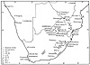 While archaeologists in both Mozambique and South Africa have increasingly recognized the critical impact that regional trade, migration, and communication networks along such rivers as the Nkomati have had on precolonial political and economic change, their research efforts have concentrated on the Indian Ocean coast and the Transvaal, the endpoints of these networks. The intervening spaces and peoples remain a rather glaring missing link, constructed in this scholarship as both hinterland and transit zone between the interior and coastal communities where the production of valuable trade commodities (e.g., iron, copper, gold) and direct exchanges with Arabs and Europeans are believed to have occurred. Viewed as a terrain across which goods and (to a lesser extent) people travel, the Lebombo/lowlands corridor appears on archaeologists' maps as a place of movement and transfer rather than one where communities live, things are produced, societies and technologies change, and meaningful events or innovations happen. Even the possibility that men and women inhabiting this area actively participated in regional trade, swapping ideas or objects or simply interacting in some way with people who passed through this cultural crossroads, has rarely entered archaeological maps or narratives on either side of the border. As a social space, Magude appears passive, inert, empty, and outside of history, significant only because of what outsiders have accomplished there. While archaeologists in both Mozambique and South Africa have increasingly recognized the critical impact that regional trade, migration, and communication networks along such rivers as the Nkomati have had on precolonial political and economic change, their research efforts have concentrated on the Indian Ocean coast and the Transvaal, the endpoints of these networks. The intervening spaces and peoples remain a rather glaring missing link, constructed in this scholarship as both hinterland and transit zone between the interior and coastal communities where the production of valuable trade commodities (e.g., iron, copper, gold) and direct exchanges with Arabs and Europeans are believed to have occurred. Viewed as a terrain across which goods and (to a lesser extent) people travel, the Lebombo/lowlands corridor appears on archaeologists' maps as a place of movement and transfer rather than one where communities live, things are produced, societies and technologies change, and meaningful events or innovations happen. Even the possibility that men and women inhabiting this area actively participated in regional trade, swapping ideas or objects or simply interacting in some way with people who passed through this cultural crossroads, has rarely entered archaeological maps or narratives on either side of the border. As a social space, Magude appears passive, inert, empty, and outside of history, significant only because of what outsiders have accomplished there. | ||||||||||||
In the one study I am aware of that focuses on sites close to Magude and addresses Iron Age developments in a lowveld region straddling the international border, the significance attached to pottery demonstrates both how archaeological mappings have tacitly marginalized this area from history and how gender ideologies have buttressed this representation. This study examines pottery remnants uncovered in three sites in Massingir, the district immediately north of Magude, and compares pottery types and decorative patterns there with findings from several sites in the northern Transvaal. Remnants from two of the Massingir sites, author Ricardo Duarte concludes, reveal the "eastward extension of Sutho [sic] populations from the Phalaborwa [area]" into Massingir, while remnants from the third site he attributes to "the Cossa [Khosa] people," who "may have come from the . . . Natal region." 18 This interpretation, illustrated in a series of visual maps, has a number of powerful, if unintended, rhetorical effects.  First, by uncritically associating "ceramic streams" with "ethnic groups," the author implies that pottery producers—women—function as passive carriers of culture and ethnic identity, unthinkingly reproducing the characteristics of ethnically defined pottery traditions instead of making conscious choices about how pots are designed. Duarte's presumptions here reflect regional archaeologists' general lack of interest in pottery production as an economic activity requiring technical skill, artistic ability, and specialized knowledge. Typically portrayed as a rudimentary, labor-intensive and "domestic" technology, the local ceramic industry is feminized and thus consigned to a secondary, supportive role in historical processes. 19 According to Martin Hall, decorative patterns in pottery were "not just a matter of applying design in the light of tradition" but a deliberate symbolic system through which householders involved in networks of "reciprocal obligation" (principally in the form of grain exchanges) would "simultaneously signify and reaffirm their mutual connectedness." 20 Even that provocative claim fails to acknowledge that this activity was gendered and that women's decisions may have had important repercussions for the boundaries of political, economic, and ethnic communities in the past. First, by uncritically associating "ceramic streams" with "ethnic groups," the author implies that pottery producers—women—function as passive carriers of culture and ethnic identity, unthinkingly reproducing the characteristics of ethnically defined pottery traditions instead of making conscious choices about how pots are designed. Duarte's presumptions here reflect regional archaeologists' general lack of interest in pottery production as an economic activity requiring technical skill, artistic ability, and specialized knowledge. Typically portrayed as a rudimentary, labor-intensive and "domestic" technology, the local ceramic industry is feminized and thus consigned to a secondary, supportive role in historical processes. 19 According to Martin Hall, decorative patterns in pottery were "not just a matter of applying design in the light of tradition" but a deliberate symbolic system through which householders involved in networks of "reciprocal obligation" (principally in the form of grain exchanges) would "simultaneously signify and reaffirm their mutual connectedness." 20 Even that provocative claim fails to acknowledge that this activity was gendered and that women's decisions may have had important repercussions for the boundaries of political, economic, and ethnic communities in the past. | 15 | |||||||||||
Second, by interpreting pottery sherds exclusively as the leavings of outsider/immigrant groups, Duarte ignores or downplays the possibility of indigenous pottery production, despite considerable oral, environmental, and documentary evidence that Massingir and neighboring areas (including Magude) have had their own ceramic industries for centuries. Another study Duarte cites, that examines nineteenth-century pottery remnants found at two former Gaza Nguni capitals, achieves the same effect by concluding that dissimilarities in the pottery's design mean that historians cannot use this form of evidence to trace the cultural or social impact of a conquering population. 21 Yet the dissimiliarities are in fact extremely suggestive, for if immigrant Nguni women did not impose their own pottery traditions on local women, or if local women who married Nguni men chose not to adopt their conquerors' material culture (as, most evidence indicates, they did not adopt their language), then we have a very complex picture of gendered interethnic relations and cultural transmission to explain. Archaeological mappings that construct this region as a terrain of passage rather than of production and of stasis rather than of action—and that treat pots as vessels manufactured by women who are non-agentic, non-innovative, dependent members of male-dominated social groups—obscure the heart of the very historical process they are trying to understand: the diffusion of distinct pottery styles across vast distances and over centuries. In so doing, they neglect such fascinating questions as the dynamic relationship between geographically extensive pottery traditions and women's self-conscious constructions of community, ethnicity, and "culture region." More specifically, they map Magude as a feminized landscape whose past neither archaeologists nor historians need to bother investigating, and they cast women as peripheral to (if not invisible in) movements of social and cultural change.
| ||||||||||||
If Magude emerges as a no-(wo)man's land in archaeological maps, travelers' maps—produced through the writings and drawings of European hunters, 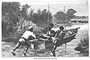 traders, adventurers, and explorers—paint a more complex picture of the Magude area, particularly in the eighteenth and nineteenth centuries. As other scholars have pointed out, Europe's geographical mission in Africa in this period laid the groundwork for colonization, not merely through the acquisition of knowledge about topography, environment, and peoples, but by enabling European governments and publics to imagine the African landscape (with its opportunities for heroism, commerce, and Christian civilization) in more detailed and more compelling ways. 22 Cartographic knowledge wielded enormous imaginative power in post-Enlightenment Europe precisely because of its scientific pretensions and of the political imperative they implied: traders, adventurers, and explorers—paint a more complex picture of the Magude area, particularly in the eighteenth and nineteenth centuries. As other scholars have pointed out, Europe's geographical mission in Africa in this period laid the groundwork for colonization, not merely through the acquisition of knowledge about topography, environment, and peoples, but by enabling European governments and publics to imagine the African landscape (with its opportunities for heroism, commerce, and Christian civilization) in more detailed and more compelling ways. 22 Cartographic knowledge wielded enormous imaginative power in post-Enlightenment Europe precisely because of its scientific pretensions and of the political imperative they implied: | ||||||||||||
| ||||||||||||
Yet travelers' maps were as imaginative in character as they were in effect—spun of desire, dreams, and illusion on the one hand and, on the other, of fear and uncertainty (and often downright discomfort). Whatever their scientific claims, their creators were charting "virgin" lands with an eye to the sensibilities of audiences at home, their gaze formed by gender and class ideologies, national identity, and an awareness that they were defining the territorial possibilities of empire. 24 | ||||||||||||
From an early date, European men of diverse origins and vocations began to express an interest in reaching or at least traversing the Magude area. Initially, they were inspired by experiences of trade and settlement elsewhere in southern Africa and by ambitions related to the unique potential of Delagoa Bay as a conduit for international commerce and a gateway to the fabled mineral wealth of "Monomotapa." 25 During the second half of the sixteenth century, the Portuguese established a commercial presence at the Bay and along the mouths of the major rivers (including the Nkomati) that emptied into it, hoping eventually to win control over the trade in ivory, gold, and copper that Africans carried overland and by river in small quantities from the interior. 26 The Nkomati River quickly earned a reputation as hazardous and impenetrable: As early as the 1550s, the Sao Benedicto was shipwrecked only a few kilometers inland from its mouth, leaving Manuel de Sousa Sepulveda, his wife and children, and most of his crew to perish in the "wilderness" from illness and starvation. 27 It was not until the 1720s, when the Dutch occupied Delagoa Bay, that Europeans wrote of efforts to tackle the river again, this time because information gathered from African traders led the Dutch to believe that the Nkomati led directly to Monomotapa's gold. Two expeditions that decade failed to get more than 50 miles upriver. The river was too shallow in places, its bed too studded with sandbars, its waters too full of hippos and crocodiles, and its banks too fiercely watched by hostile "natives" for the Dutch crews to risk attempting to follow it to its source. However, Dutch interest in the Nkomati as a route to the interior persisted, and for the remaining years of their presence at Delagoa Bay they pondered its navigational challenges and probable geographic extent and grilled African travelers who arrived there about the routes they had taken, the peoples they had passed, and the natural resources they had noticed along the way. 28 | 20 | |||||||||||
European fantasies about the riches lying at the origins of the Nkomati assumed an even more mythical quality in the later eighteenth and early nineteenth centuries, as the prospect of reaching it from Delagoa Bay seemed increasingly remote. Austrian merchants who plied the river in small boats managed to push the limits of European trade contacts further inland by the 1780s. They returned with tales of a great king, sovereign of all other African rulers in the region, who possessed many lands, great power, and vast stores of ivory supplied by African porters who regularly delivered tusks to him from the highlands to the west. 29 British traders and hunters who attempted to navigate further upriver in the mid-nineteenth century were prevented from doing so by the Portuguese, as the battle for commercial supremacy at Delagoa Bay—and over suppression of the slave trade—heated up. 30 Yet two subsequent Portuguese voyages hoping to reach the river's source turned back, well before achieving their destination and at least 30 miles downriver from the present limits of Magude district. 31 In fact, although d'Oliveira (writing in the early 1870s) refers to the claims of other travelers that the Nkomati was navigable through the Lebombo mountains and as far as the Zoutpansberg in the northern Transvaal, no Europeans are on record as having got even as far the Magude area until 1891, and then only because the Portuguese crew slid into the river far enough upstream, at the Nkomati's confluence with the Sabié River to the southwest, that they could sail with little difficulty downriver past Magude and to the coast. 32  Tense confrontations with African inhabitants (or the desire to avoid them) were sometimes cited as the reason for aborted voyages, as were illness, inadequate provisions, and inclement weather. However, travelers in their narratives highlighted the treacherous river itself as their most formidable opponent. The publicized debate about the Nkomati's precise course and the bewildering array of names used to refer to it throughout this time—Uncomogazi, Comati, Manyissa, Uhlwandle, King George's, and Espirito Santo, to list a few—reflect its status in the imaginations of Europeans who huddled around Delagoa Bay harbor, wondering what the unfriendly serpentine waters were hiding from them. 33 Tense confrontations with African inhabitants (or the desire to avoid them) were sometimes cited as the reason for aborted voyages, as were illness, inadequate provisions, and inclement weather. However, travelers in their narratives highlighted the treacherous river itself as their most formidable opponent. The publicized debate about the Nkomati's precise course and the bewildering array of names used to refer to it throughout this time—Uncomogazi, Comati, Manyissa, Uhlwandle, King George's, and Espirito Santo, to list a few—reflect its status in the imaginations of Europeans who huddled around Delagoa Bay harbor, wondering what the unfriendly serpentine waters were hiding from them. 33 | ||||||||||||
The Magude area itself does not seem to have been reached by Europeans on foot, or mapped on paper, until the late 1830s, when Louis Trigardt led the first successful European overland trip from the Transvaal to Delagoa Bay. An ambitious extension of the Great Trek, this expedition had as its primary objective the opening of an independent trade route to the sea for the newly established voortrekker republics. 34 Trigardt and most other members of his party who survived the journey died of malaria or sleeping sickness soon after their arrival in Lourenço Marques. 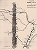 Trigardt's diary provided the earliest written observations of the Lebombos and made a critical contribution to later European forays into the area. 35 For unknown reasons, though, Trigardt's entries became unusually terse immediately after he crossed the Lebombos into the western borderlands of what would later be Magude district; and we learn little from this part of his narrative except that he visited the kraals of two chiefs along the "Wanetzi" River, shot at hippos, spied on elephants, watched his cattle die, and noted a few species of local vegetation. Even Trigardt's route map changes abruptly east of the "Bombo Hills," depicting only major rivers and the course his party followed—drawn as a virtual beeline through blank space—along the Nkomati to Lourenço Marques. Trigardt's diary provided the earliest written observations of the Lebombos and made a critical contribution to later European forays into the area. 35 For unknown reasons, though, Trigardt's entries became unusually terse immediately after he crossed the Lebombos into the western borderlands of what would later be Magude district; and we learn little from this part of his narrative except that he visited the kraals of two chiefs along the "Wanetzi" River, shot at hippos, spied on elephants, watched his cattle die, and noted a few species of local vegetation. Even Trigardt's route map changes abruptly east of the "Bombo Hills," depicting only major rivers and the course his party followed—drawn as a virtual beeline through blank space—along the Nkomati to Lourenço Marques. | ||||||||||||
Between the time of Trigardt's journey in the late 1830s and Portugal's occupation of southern Mozambique in the 1890s, a number of European overland expeditions circled around and occasionally crossed the area north and west of the Nkomati bend. Embarking from the Transvaal, Natal, or Portuguese settlements at Inhambane and Delagoa Bay, European men driven by visions of adventure, profit, and conquest made their slow and perilous way across the lands bounded by the Save River on the north, the Tugela River on the south, Lydenburg on the west, and the Indian Ocean on the east. The earliest of these journeys, from the 1850s to the 1870s, were undertaken by British and Portuguese hunter-traders in search of ivory (and sometimes gold), particularly in the region of the Lebombos and the Zoutpansberg, where João Albasini, a Portuguese commercial hunter and gun- and slave-trader and aspiring state-builder from Lourenço Marques, had established a settlement on the fringes of Boer society and beyond the reach of the Swazi and Gaza Nguni states. 36 With their eyes usually trained on both "wild game" and evidence of African involvement in the coastal trade, these men sought in part to map the land and river networks along which valuable commodities were being (or could be) moved between the interior and Portuguese-controlled ports. Some also devoted considerable effort to charting and evaluating natural resources (water, soils, minerals, flora, and fauna) as well as disease (human and animal), hazardous or difficult aspects of the terrain, and other potential obstacles to European movement. Not surprisingly, when African people figure in these accounts, it is typically either as "Kaffir" members of expedition parties or as another feature of the landscape that Europeans had to negotiate in passing. | ||||||||||||
From about 1870 on, sportsmen preoccupied with trails of animal spoor and entrepreneurial hunters concerned with profit were increasingly replaced by professional explorers focused, for the twin purposes of commerce and science, on determining the exact names and latitudinal locations of strategic elements of the region's geography. 37 These mappings, which were produced by men who considered themselves civil servants of imperial governments, described the position and contents of African settlements in greater detail and classified their inhabitants carefully according to "tribe" and political allegiance. In part, these efforts aimed at evaluating the economic potential and governability of the natives as future colonial subjects. However, understanding native politics became especially important in the 1880s and early 1890s, when British and Portuguese competition for southern Mozambique intensified and the Portuguese in particular, in their endeavor to wrest from Ngungunyana's hands the control over the region's population and resources, turned their attention to discovering the fault lines in Gaza Nguni power. 38 This task required explorers to ascertain the identity, influence, and loyalty of Ngungunyana's subordinate chiefs and to interpret popular attitudes toward Nguni overlords, with the result that travelers' mappings for this period are thick with creatively rendered African place-names and chiefdoms but also with social commentary suggesting that Gaza rule was neither as happy nor as firmly rooted as its spokesmen pretended it to be.  As a result, travel-roughened European men appear oddly sensitive to signs of illness and famine among Africans, to sightings of "Amatonga" 39 captives and refugees (above all when they were women and children), and to the ways in which indigenous peoples displayed differences or commonalities of ethnic identity among themselves. Body decorations such as tattoos, pierced ears, hairstyles, and dress, along with diet and such aspects of material culture as architecture provided these imperial cartographers with convenient indicators of cultural persistence (or resistance, the only other option they recognized) in subject populations—evidence, they believed, that such people might readily be convinced to become Portuguese or British instead. As a result, travel-roughened European men appear oddly sensitive to signs of illness and famine among Africans, to sightings of "Amatonga" 39 captives and refugees (above all when they were women and children), and to the ways in which indigenous peoples displayed differences or commonalities of ethnic identity among themselves. Body decorations such as tattoos, pierced ears, hairstyles, and dress, along with diet and such aspects of material culture as architecture provided these imperial cartographers with convenient indicators of cultural persistence (or resistance, the only other option they recognized) in subject populations—evidence, they believed, that such people might readily be convinced to become Portuguese or British instead. | ||||||||||||
In this age of overland travel, the area of present-day Magude district was not itself a destination of Europeans, and its depiction in visual maps did not change much between Trigardt's day and the final decade of the nineteenth century. 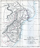 Circled around or quickly passed through, it continued to be drawn as a blank space bounded on the west by the Lebombos and crisscrossed simply by rivers and the trails blazed by European explorers. If any part of it consistently interested these men, it was the dominant physical features that today define the district's edges: the Nkomati River and its major affluents, with their practical value as commercial transport routes and symbolic importance as openings to the interior; and the Lebombo mountains, a rugged and liminal "frontier" terrain beyond the reach of Portuguese, Boer, and British influence but through which all three groups hoped eventually to build wagon roads and railways. Circled around or quickly passed through, it continued to be drawn as a blank space bounded on the west by the Lebombos and crisscrossed simply by rivers and the trails blazed by European explorers. If any part of it consistently interested these men, it was the dominant physical features that today define the district's edges: the Nkomati River and its major affluents, with their practical value as commercial transport routes and symbolic importance as openings to the interior; and the Lebombo mountains, a rugged and liminal "frontier" terrain beyond the reach of Portuguese, Boer, and British influence but through which all three groups hoped eventually to build wagon roads and railways. 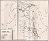 Within these limits, however, empty spaces were not terra incognita, which is what some scholars have assumed the blanks on colonial maps represented; they were not perilous "margins and thresholds," "reminders of the failure of knowledge and hence the tenuousness of possession." 40 In the case of Magude, empty spaces between rivers and mountains signified land that, as far as whites were concerned, was both barely inhabited and practically uninhabitable—wild and dangerous ("a hunter's elysium"), 41 infested with tsetse fly ("a pestilential place"), 42 alternating between monotonous sandy plains and rocky hills bristling with thorn trees 43 and so ill-favored that much of it was left, at least for a time, as a boundary zone between territories of Swazi and Gaza Nguni tribute-taking. 44 According to travelers' mappings, it was a place that both scorned and justified European conquest. While it was desolate and unruly, though, it also had strategic value, and, while it was believed to be thinly settled, it was home to the "Cossa" people, whose leaders by the 1890s were appealing to the Portuguese for an alliance that would strengthen them against Ngungunyana. In turn, the Portuguese looked to the "Cossa" as their only hope for tapping into the dynamic trade economy of the Lebombo/Zoutpansberg triangle. 45 Within these limits, however, empty spaces were not terra incognita, which is what some scholars have assumed the blanks on colonial maps represented; they were not perilous "margins and thresholds," "reminders of the failure of knowledge and hence the tenuousness of possession." 40 In the case of Magude, empty spaces between rivers and mountains signified land that, as far as whites were concerned, was both barely inhabited and practically uninhabitable—wild and dangerous ("a hunter's elysium"), 41 infested with tsetse fly ("a pestilential place"), 42 alternating between monotonous sandy plains and rocky hills bristling with thorn trees 43 and so ill-favored that much of it was left, at least for a time, as a boundary zone between territories of Swazi and Gaza Nguni tribute-taking. 44 According to travelers' mappings, it was a place that both scorned and justified European conquest. While it was desolate and unruly, though, it also had strategic value, and, while it was believed to be thinly settled, it was home to the "Cossa" people, whose leaders by the 1890s were appealing to the Portuguese for an alliance that would strengthen them against Ngungunyana. In turn, the Portuguese looked to the "Cossa" as their only hope for tapping into the dynamic trade economy of the Lebombo/Zoutpansberg triangle. 45 | 25 | |||||||||||
Yet it was the gendered quality of travelers' cartography of southern Mozambique that made the argument for European colonization here so compelling—and that made it possible to imagine transforming the Magude area from marginal wilderness into mastered terrain. African women are sprinkled throughout narrative mappings of this region in a number of revealing symbolic roles. They are the fetchers of food and drink for European visitors, the tenders of native gardens, diggers in the soil for roots and gatherers of wild fruit in times of famine. Thus bound to the soil and the provision of sustenance, women blend into travelers' constructions of the natural landscape, as passive and disconnected from history as the "bush" itself. Yet at the same time they domesticate the wildnerness, transforming it into a place where white men might live in relative material comfort and emotional safety. 46 As bearers of tattoos, decorative ornaments, and dress, women also served for Europeans as key signifiers of ethnic divisions, notably between the Gaza Nguni "invaders" and their "Amatonga" subjects. 47 Just as, in European eyes, women were necessary to tame the wilderness, political domination of one tribe over another was believed to be inscribed on women's bodies. Thus a local woman who did not adopt Nguni fashions of dress or personal adornment was presumed to still identify with her own people rather than with her conquerors. In this respect, European interest in "Vatua" (Nguni) marriage patterns hints at another way in which women's bodies were metaphorically associated with the field of conquest. Portuguese writers in particular liked to point out that "the Vatua has great contempt for women outside his race" and that, because Nguni men would marry only "pure Nguni" women, "the Vatuas are very few and the Ma-changana are very many." In Portuguese eyes, this practice was a source of vulnerability for the Gaza state. On the one hand, it meant that the Nguni ruling class remained a tiny minority in numerical terms; on the other hand, it convinced them that Gaza hegemony was fundamentally incomplete—that, by failing to engage with (or incorporate) their female subjects in the domains of family, sexuality, and everyday life, male members of the Gaza elite had failed to lay the social groundwork necessary for enduring political power. 48 | ||||||||||||
Finally, in travelers' narrative mappings of southern Mozambique, women are emblematic of the suffering and peculiarly African forms of tyranny from which European colonization was supposed to save the continent. As casualties of drought and famine, women are portrayed as uniquely vulnerable to the region's harsh environment. 49 As refugees fleeing from Gaza marauders, as widows of executed "Amatonga" men sent by Ngungunyana to establish villages in the wilderness, or as captives sold to Muslim and "Banyan" traders to serve as wives or "prostitutes," women appear as the helpless victims of cruel (and often depraved) male oppressors—a category that occasionally also includes Europeans, such as when St. Vincent Erskine takes a group of women hostage in order to induce a local man to accompany them as guide. 50  And in one allegory-like passage, describing a "dark night" scene in which a male "witch doctor" treats a female patient by accusing the "old women" in the all-female audience of casting an evil eye at her, a Portuguese traveler suggests that women are at the mercy of "savage" indigenous customs as well. 51 Thus in what the Comaroffs have aptly called the "moral geography" of imperial exploration, travelers also mapped southern Mozambique in a way that "cleared the ethical ground for . . . colonialism," 52 but in starkly gendered colors suggesting that what was most in need of European salvation was also distinctly feminine. And in one allegory-like passage, describing a "dark night" scene in which a male "witch doctor" treats a female patient by accusing the "old women" in the all-female audience of casting an evil eye at her, a Portuguese traveler suggests that women are at the mercy of "savage" indigenous customs as well. 51 Thus in what the Comaroffs have aptly called the "moral geography" of imperial exploration, travelers also mapped southern Mozambique in a way that "cleared the ethical ground for . . . colonialism," 52 but in starkly gendered colors suggesting that what was most in need of European salvation was also distinctly feminine. | ||||||||||||
Significantly, images of women are very different in the two existing examples of travelers' writing from near present-day Magude district itself. Roughly ten years and perhaps twenty miles separated the arrival of Diocleciano Fernandes das Neves, a Portuguese ivory hunter en route to the Transvaal, and that of James Frederick Elton, a British civil servant and explorer, along the Nkomati River at a large village that each man believed was chief "Magud's" capital in the land known to them as Cossine. 53 Magudzu Khosa, according to oral traditions recorded by early Portuguese administrators (see below), belonged to at least the ninth generation of Khosa immigrants to dominate the lands and autochthonous peoples between the Mazimhlopes River and the Nkomati, including the area within the district's current boundaries, since the mid-eighteenth century. By the time of these visits, in 1860 and 1870 respectively, Magudzu had achieved such power that he was considered a "great chief" by Europeans and carried sufficient weight in regional politics that his military alliance with Mzila against Mawewe—the two warring sons of Soshangane in the Gaza succession war of 1858-62—was an important factor (along with Portuguese-supplied weapons) in the former's victory. 54 | ||||||||||||
Neither das Neves nor Elton met Chief Magudzu himself. Despite the rather tense political climate and the discrepancies of time and place, these two travelers recorded similar impressions of Magudzu's domain in which women were symbolically crucial actors, helping to define not only the visitors' understanding of geography but also the gendered terms on which the area was deemed accessible to Europeans. Das Neves narrates his sojourn here as a series of pleasantly surprising encounters between himself and "the natives," in a setting he describes as a town laid with streets and avenues and richly provisioned to accommodate his party. In nearly all of these encounters, women function as intermediaries of some kind, instrumental to his reception by the community and to the relationship he forges with local authorities. As in the following passage, women are also implicitly sexualized and are represented as markers of European commercial and cultural influence through their desire to possess imported commodities, again, for purposes of bodily decoration: | ||||||||||||
| 30 | |||||||||||
Women do not occupy as prominent a place in Elton's more brief description of his visit. However, Elton's account of a hippo-shooting in the Nkomati is remarkably similar to das Neves': the armed white man establishes his popularity among local people by killing the huge beast and then allowing them to divide and consume the carcass among themselves. And in a summary reviewing his travels, Elton also comments on the unusual assertiveness of the women of Khoseni: "At Magud's we were besieged and annoyed by women, who came down to our camp after the men had retired for the night." 56 In an area otherwise portrayed as disorderly and unappealing, the common elements in the narratives of these two travelers are extremely important in the mapping of "Magud's" as a place open—even hospitable—to European colonization, in large part because of how the authors gender the landscape. European men win over the natives by taming the wilderness (in the shape of a hippo) and transforming it into a community feast, thus appropriating roles usually assigned to African women, and the women themselves not only exhibit signs of European "civilization" in their behavior and material culture but also court contact with imperial travelers and aggressively try to negotiate the visitors' presence to personal advantage. If, in the genre of mapping to which these two accounts belong, women are symbolically associated with territory targeted for colonization and the incorporation (or bodily inscription) of women is essential to the success of a political project, then the women at "Magud's" appear to be simultaneously marking and mediating the boundaries of imminent imperial conquest—in a very powerful way, legitimizing (because tacitly asking for) European colonial rule. While these particular mappings of Magude represent women as willful and consequential historical actors, and thus very different from the voiceless victims of other travelers' accounts from southern Mozambique, they also reduce the women of Magude to clamoring admirers of all things European, easily persuaded to abandon their own communities and traditions for jewelry, hippopotamus meat, and the white men who deliver them. 57
| ||||||||||||
Magude does not appear in its present-day form in archaeologists' or travelers' mappings of the region; and as the foregoing discussion suggests, it is difficult today to reconstruct how the peoples who inhabited this area before the twentieth century would have defined the spatial unit(s) to which they and their histories belonged.  Whether we highlight trade, politics, or topography, territorial identity here seems stubbornly ambiguous in the precolonial period, for African communities here were oriented toward both the coast and the Transvaal, east-west river networks and north-south mountain chains, Portuguese and South African whites, local chiefs and invader-kings. Moreover, these mapmakers' perceptions of African landscapes were structured by assumptions about gender (and race) in ways that particularly obscure not only women's understandings of spatial organization but also the social, cultural, or political communities within which women might have located their lives. If we rely only on these maps, perhaps all we can state with confidence is that local mappings of the Magude area prior to colonial conquest were still largely independent of European influence despite the increasing intrusion of imperial exploration and commerce in Africans' midst. Even Portuguese travelers on the eve of colonization—conducting topographic surveys to determine the penetrability of the interior by river and to demarcate the international border between Moçambique colony and the Transvaal—found in the Lebombos Africans who "did not know whether they were Boer or Portuguese" and women traveling westward through the hills (across the very boundary the white men were creating) in search of ochre for painting their hair. 58 Whether we highlight trade, politics, or topography, territorial identity here seems stubbornly ambiguous in the precolonial period, for African communities here were oriented toward both the coast and the Transvaal, east-west river networks and north-south mountain chains, Portuguese and South African whites, local chiefs and invader-kings. Moreover, these mapmakers' perceptions of African landscapes were structured by assumptions about gender (and race) in ways that particularly obscure not only women's understandings of spatial organization but also the social, cultural, or political communities within which women might have located their lives. If we rely only on these maps, perhaps all we can state with confidence is that local mappings of the Magude area prior to colonial conquest were still largely independent of European influence despite the increasing intrusion of imperial exploration and commerce in Africans' midst. Even Portuguese travelers on the eve of colonization—conducting topographic surveys to determine the penetrability of the interior by river and to demarcate the international border between Moçambique colony and the Transvaal—found in the Lebombos Africans who "did not know whether they were Boer or Portuguese" and women traveling westward through the hills (across the very boundary the white men were creating) in search of ochre for painting their hair. 58 | ||||||||||||
The space now known as Magude is a colonial invention, created by Portuguese officials after 1895 as part of a cartographic project "to legitimise the reality of conquest and empire . . ., [to] create myths which would assist in the maintenance of the territorial status quo" of colonial overrule. 59 Like all mappings of colonization, those which first brought Magude into being were explicit expressions of power, more direct, arbitrary, and ambitious than any produced for this area before. Yet, to a very great extent, early colonial maps of this part of Mozambique were also exercises in illusion and fantasy, their excessive thoroughness and attention to detail proportional to the tenuousness of Portuguese control on the ground. Indeed, colonizers' mappings of Magude—whether narrative, pictorial, or (in a third category typical of this genre) numeric—embodied visions of domination that did not always correspond to existing relationships between Europeans and Africans or reflect the state of Portuguese knowledge about lands purportedly occupied and populations allegedly conquered or lured to the Portuguese side. Needing to demonstrate to other imperial powers, to themselves, and to their African subjects the firmness of their possession, the value of the territory they had acquired, and the legitimacy of their governance, Portuguese colonial mapmakers turned from charting the physical terrain to documenting information about the social, political, and economic landscape—everything they needed to establish or create the impression of a functioning administration. Their efforts were supplemented (and often surpassed) by the cartographic labors of Swiss missionaries and other European settlers, whose own ambitions of Christian conversion or commercial gain required that they too develop representational systems for organizing colonized places, for getting to know the natives in ways that would best facilitate the operation of their own forms of power. Not surprisingly, then, colonizers' maps tended to be as variable as the peoples they were striving to rule—and as profoundly shaped by intersecting European and African gender ideologies. | ||||||||||||
In chronological terms, the earliest colonial mappings for Magude charted Portuguese military and political conquest and the ensuing imposition of colonial administrative structures. For southern Mozambique in general, maps of conquest produced during the 1890s highlighted Portuguese military campaigns and the sites of strategic defeats of Ngungunyana's forces. 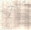 Where armed conquest was not necessary, as among the chiefdoms along the upper Nkomati, the publication of "treaties of vassalage" served as stakes marking the frontier of "effective occupation"—demanded by European participants in the Berlin Conference of 1884-85 as a precondition for recognizing imperial claims to African territory—as the Portuguese moved this frontier north and westward toward the Lebombo hills. Vassal chiefdoms were the building blocks of a colonial administration, grouped together first under the authority of military posts and then into circumscriptions and districts that were assigned to Portuguese officials and within which appointed African chiefs (régulos) were to serve as frontline agents of colonial government, conscripting labor and collecting taxes, and replaced or eliminated when necessary to ensure the continued functioning of the system. 60 In November 1895, a few short weeks after the Portuguese army's final routing of Gaza forces at the Battle of Coolela, one such treaty of vassalage was signed by the fifteen-year-old chief Xongela Khosa—one of Magudzu's youngest sons, chosen as his successor after the death of the "great chief" in 1885. Where armed conquest was not necessary, as among the chiefdoms along the upper Nkomati, the publication of "treaties of vassalage" served as stakes marking the frontier of "effective occupation"—demanded by European participants in the Berlin Conference of 1884-85 as a precondition for recognizing imperial claims to African territory—as the Portuguese moved this frontier north and westward toward the Lebombo hills. Vassal chiefdoms were the building blocks of a colonial administration, grouped together first under the authority of military posts and then into circumscriptions and districts that were assigned to Portuguese officials and within which appointed African chiefs (régulos) were to serve as frontline agents of colonial government, conscripting labor and collecting taxes, and replaced or eliminated when necessary to ensure the continued functioning of the system. 60 In November 1895, a few short weeks after the Portuguese army's final routing of Gaza forces at the Battle of Coolela, one such treaty of vassalage was signed by the fifteen-year-old chief Xongela Khosa—one of Magudzu's youngest sons, chosen as his successor after the death of the "great chief" in 1885.  Although European accounts of Xongela's actions at this time are not entirely consistent and hint at complex behind-the-scenes dynamics for which we have no direct evidence, it is clear that the boy felt considerable pressure from his mother and uncle-regent Mafavaze to accept vassal status in order to secure Portuguese protection from Ngungunyana's armies, which were increasingly threatening Khoseni after tensions developed between Mafavaze and the new Gaza ruler. 61 Because of the size of the territory then under Khosa rule, this area was constituted as a military post and then a circumscription on its own—first called Cossine and later, following the incorporation of additional chiefdoms, Magude, after the Khosa chief with whom the Portuguese had first had direct contact and with whose personal authority they associated this strategically valuable area. Although European accounts of Xongela's actions at this time are not entirely consistent and hint at complex behind-the-scenes dynamics for which we have no direct evidence, it is clear that the boy felt considerable pressure from his mother and uncle-regent Mafavaze to accept vassal status in order to secure Portuguese protection from Ngungunyana's armies, which were increasingly threatening Khoseni after tensions developed between Mafavaze and the new Gaza ruler. 61 Because of the size of the territory then under Khosa rule, this area was constituted as a military post and then a circumscription on its own—first called Cossine and later, following the incorporation of additional chiefdoms, Magude, after the Khosa chief with whom the Portuguese had first had direct contact and with whose personal authority they associated this strategically valuable area. | 35 | |||||||||||
Negotiations with Afrikaner leaders in the Transvaal and their British successors produced another kind of conquest map relevant to Magude: boundary treaties and surveyors' reports demarcating the outer limits of Portuguese territory through the Lebombos. 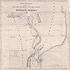 In a second, administrative category of colonizers' mappings of Magude, censuses, 62 circumscription reports, 63 and officially documented chiefly genealogies 64 were intended to organize access to the resources of conquered and marked African spaces, enabling the Portuguese to collect taxes, enforce laws, round up labor, and regulate the movements of the colonized population. For the most part, because these maps were structured around their authors' typically shaky understanding of local political arrangements, and because Portuguese officials were preoccupied with substantiating their claim to be governing through indigenous hierarchies headed by all-powerful chiefs, administrative mappings of early colonial Magude tended to foreground the ruling credentials of appointed régulos and their subordinates and to have little to say about the rest of the population. Swiss Presbyterian missionaries, who extended their evangelizing campaign from the northern Transvaal into the Magude area in the 1880s, generated much richer information about the residents of Cossine in this respect. The Swiss, who authored very detailed pictorial maps of Magude during the early colonial period, represented their record of Christian conquest through the progress of their cartographic knowledge of the region, focusing primarily on the physical locations and clan identities of African communities situated near mission stations and along European travel routes. 65 In a second, administrative category of colonizers' mappings of Magude, censuses, 62 circumscription reports, 63 and officially documented chiefly genealogies 64 were intended to organize access to the resources of conquered and marked African spaces, enabling the Portuguese to collect taxes, enforce laws, round up labor, and regulate the movements of the colonized population. For the most part, because these maps were structured around their authors' typically shaky understanding of local political arrangements, and because Portuguese officials were preoccupied with substantiating their claim to be governing through indigenous hierarchies headed by all-powerful chiefs, administrative mappings of early colonial Magude tended to foreground the ruling credentials of appointed régulos and their subordinates and to have little to say about the rest of the population. Swiss Presbyterian missionaries, who extended their evangelizing campaign from the northern Transvaal into the Magude area in the 1880s, generated much richer information about the residents of Cossine in this respect. The Swiss, who authored very detailed pictorial maps of Magude during the early colonial period, represented their record of Christian conquest through the progress of their cartographic knowledge of the region, focusing primarily on the physical locations and clan identities of African communities situated near mission stations and along European travel routes. 65 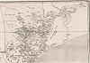 African men (and, rarely, women) were more centrally involved in the creation of these maps than in the maps of nineteenth-century travelers: Censuses depended on tallies provided by village headmen; chiefly genealogies depended on oral traditions solicited from male elders; and knowledge of footpaths and of the distribution of clans depended on the cooperation of everyone from chiefs to the ordinary inhabitants of the countryside. Yet greater African participation in the mapmaking efforts of early colonizers seems often to have made the task more difficult rather than less, since, as Europeans learned more about the complexity of indigenous politics and culture, they had difficulty forcing this knowledge into the limited concepts and categories their governments provided. As one frustrated Portuguese official stationed in Cossine complained to the governor of Lourenço Marques district in 1897, after being told to count the régulos under his authority: African men (and, rarely, women) were more centrally involved in the creation of these maps than in the maps of nineteenth-century travelers: Censuses depended on tallies provided by village headmen; chiefly genealogies depended on oral traditions solicited from male elders; and knowledge of footpaths and of the distribution of clans depended on the cooperation of everyone from chiefs to the ordinary inhabitants of the countryside. Yet greater African participation in the mapmaking efforts of early colonizers seems often to have made the task more difficult rather than less, since, as Europeans learned more about the complexity of indigenous politics and culture, they had difficulty forcing this knowledge into the limited concepts and categories their governments provided. As one frustrated Portuguese official stationed in Cossine complained to the governor of Lourenço Marques district in 1897, after being told to count the régulos under his authority: | ||||||||||||
| ||||||||||||
 Nonetheless, colonial administrative cartography, whether produced by Portuguese officials or Swiss missionaries, had more tangible effects on Africans' lives than did previous forms of mapping, and helped to transform European dreams of political and spiritual domination into the everyday realities of rule even in the face of strong African opposition. Conquest and administrative mappings of Cossine/Magude circumscription reveal that this area lived up to its earlier reputation as an unruly frontier zone whose inhabitants did not succumb easily to colonial space discipline, whether in the form of new place-names and boundary lines or of systems for counting, coding, and fixing the location of colonial subjects. The 1897 uprising led by Maguiguana Khosa depended on the participation of some sympathetic chiefs in Cossine, and reached its tragic climax with Maguiguana's execution in the remote northwest corner of the circumscription. Nonetheless, colonial administrative cartography, whether produced by Portuguese officials or Swiss missionaries, had more tangible effects on Africans' lives than did previous forms of mapping, and helped to transform European dreams of political and spiritual domination into the everyday realities of rule even in the face of strong African opposition. Conquest and administrative mappings of Cossine/Magude circumscription reveal that this area lived up to its earlier reputation as an unruly frontier zone whose inhabitants did not succumb easily to colonial space discipline, whether in the form of new place-names and boundary lines or of systems for counting, coding, and fixing the location of colonial subjects. The 1897 uprising led by Maguiguana Khosa depended on the participation of some sympathetic chiefs in Cossine, and reached its tragic climax with Maguiguana's execution in the remote northwest corner of the circumscription.  For the Portuguese, the gravity of this belated challenge to colonial rule is reflected in the relatively large number of histories and graphic mappings of this event that portray Mousinho de Albuquerque's military campaign against Maguiguana as a heroic, divinely predestined quest pitting Portuguese soldiers against hunger, illness, treacherous terrain, deceitful Africans, and, finally, a "dense forest" in which the great Gaza warrior is found "cowering" alone in a tree. 67 For the Portuguese, the gravity of this belated challenge to colonial rule is reflected in the relatively large number of histories and graphic mappings of this event that portray Mousinho de Albuquerque's military campaign against Maguiguana as a heroic, divinely predestined quest pitting Portuguese soldiers against hunger, illness, treacherous terrain, deceitful Africans, and, finally, a "dense forest" in which the great Gaza warrior is found "cowering" alone in a tree. 67 | ||||||||||||
 Regulados were eliminated, added, or redefined; Magude circumscription was passed back and forth between Lourenço Marques and Gaza districts (transferred in 1946 to Gaza, then in 1970 back to Lourenço Marques); and, between 1945 and 1974, colonial officials wrote numerous reports trying to pin down the territorial extent, population, and influence of Magude's chiefs—especially, again, in the poorly regulated hilly strip along the border. 68 Regulados were eliminated, added, or redefined; Magude circumscription was passed back and forth between Lourenço Marques and Gaza districts (transferred in 1946 to Gaza, then in 1970 back to Lourenço Marques); and, between 1945 and 1974, colonial officials wrote numerous reports trying to pin down the territorial extent, population, and influence of Magude's chiefs—especially, again, in the poorly regulated hilly strip along the border. 68 | ||||||||||||
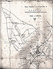 Xipissana's flight from Magude was prototypical in another way as well, for colonial administrative cartography often feminized its instability. On the one hand, administrative mapmakers represented African authority structures, social systems, and economies as thoroughly male-dominated, in large part because European assumptions dovetailed with the gender ideologies of their male African informants. On the other hand, because the responsibilities of African women for food production and family life were critical both to Portuguese plans to redirect male energies into the colonial economy and to Swiss plans to disseminate Christianity through male African evangelists, it was extremely important that women behave in what colonizers believed an appropriately submissive manner, and it was deeply worrisome when they showed themselves to possess any degree of independence. Thus Pedro Mesquito de Pimental, nearing the end of his long tenure as administrator of Magude circumscription (a period during which he was also, according to elderly interviewees, living with a local woman in common-law marriage), articulated the perceived connection between the weakness of colonial government and African gender relations in an impassioned critique of the Portuguese regime for neglecting to codify "customary law": Xipissana's flight from Magude was prototypical in another way as well, for colonial administrative cartography often feminized its instability. On the one hand, administrative mapmakers represented African authority structures, social systems, and economies as thoroughly male-dominated, in large part because European assumptions dovetailed with the gender ideologies of their male African informants. On the other hand, because the responsibilities of African women for food production and family life were critical both to Portuguese plans to redirect male energies into the colonial economy and to Swiss plans to disseminate Christianity through male African evangelists, it was extremely important that women behave in what colonizers believed an appropriately submissive manner, and it was deeply worrisome when they showed themselves to possess any degree of independence. Thus Pedro Mesquito de Pimental, nearing the end of his long tenure as administrator of Magude circumscription (a period during which he was also, according to elderly interviewees, living with a local woman in common-law marriage), articulated the perceived connection between the weakness of colonial government and African gender relations in an impassioned critique of the Portuguese regime for neglecting to codify "customary law": | 40 | |||||||||||
| ||||||||||||
Especially troublesome in European eyes, and prominent in narrative forms of administrative mapping throughout the colonial period, were two categories of women.  One consisted of female chiefs, male chiefs' mothers and first wives, female spirit mediums, and other women who enjoyed traditional forms of political or social influence. The other category consisted of women whose lives did not conform to European notions of traditional female behavior—women, for example, who traded and drank wine at Banyan (Indian) shops, had sexual relationships with white settlers, or migrated to work on white-owned plantations. As elsewhere on the continent, where European officials were bewildered by the unwillingness of African women to conform to colonial notions of proper ladylike comportment, women appear in these sources as potential dishevelers of systems the Portuguese developed to circumscribe the territory and population of Magude and as moral threats to the Swiss evangelization campaign and to the spiritual integrity of African converts. 70 Indeed, oral accounts of Maguiguana's tragic end make a point of evoking European uneasiness about—and desire to eliminate—the powers of Magude's women at the moment of Khoseni's final defeat by the forces of colonization: Mousinho de Albuquerque, interviewees recalled, forced Maguiguana's mother to carry the slain rebel's severed head over roughly 100 kilometers of harsh terrain, from the site of his murder to the colonial command post at Magude town. It is difficult to imagine a more cruel example of either the manifestation of European gender fears or the feminization of colonial conquest in Africa. 71 One consisted of female chiefs, male chiefs' mothers and first wives, female spirit mediums, and other women who enjoyed traditional forms of political or social influence. The other category consisted of women whose lives did not conform to European notions of traditional female behavior—women, for example, who traded and drank wine at Banyan (Indian) shops, had sexual relationships with white settlers, or migrated to work on white-owned plantations. As elsewhere on the continent, where European officials were bewildered by the unwillingness of African women to conform to colonial notions of proper ladylike comportment, women appear in these sources as potential dishevelers of systems the Portuguese developed to circumscribe the territory and population of Magude and as moral threats to the Swiss evangelization campaign and to the spiritual integrity of African converts. 70 Indeed, oral accounts of Maguiguana's tragic end make a point of evoking European uneasiness about—and desire to eliminate—the powers of Magude's women at the moment of Khoseni's final defeat by the forces of colonization: Mousinho de Albuquerque, interviewees recalled, forced Maguiguana's mother to carry the slain rebel's severed head over roughly 100 kilometers of harsh terrain, from the site of his murder to the colonial command post at Magude town. It is difficult to imagine a more cruel example of either the manifestation of European gender fears or the feminization of colonial conquest in Africa. 71 | ||||||||||||
Colonizers' maps also took the form of ethnographic cartography, a category in which Magude's position was similarly pivotal and ambivalent. Yet whereas administrative mapping sought to identify (male) individuals at the apex of African political structures in order to redefine them as instruments of Portuguese rule, the objective of ethnographic mapping was to people the colonized landscape: to name the clans or tribes living within Magude's borders, draw boundaries around the physical space each group supposedly occupied, and study the "customs and habits" characteristic of each. Produced by both Portuguese officials and Swiss missionaries, ethnographic mappings thus divided colonial subjects according to distinctions based on everything from religious and political ritual to kinship systems, material culture, language, song, and dance. 72 As part of their effort to solidify power over Africans by disaggregating them, the creators of these maps initially emphasized differences between immigrant and indigenous clans, between Nguni and "Tsonga," and among the various subgroups of the Tsonga "race," of which the "Djonga" (including the Khosa clan) were said to be the most true and were particularly associated with the Magude area. 73 However, a mapping strategy that at first drew attention to historic linkages between Magude and South Africa and that ranked "native races" according to ethnocentric notions of purity, technological sophistication, and ancestral origins was eventually overshadowed by a cartography more narrowly focused on the peculiar race dynamics of Mozambique's colonial society. From the 1930s on, Portuguese anthropologists became increasingly preoccupied, on the one hand, with "miscegenation," as sexual unions among Africans, Europeans, and Asians began to transform the demographic landscape and to complicate previous official racial and ethnic categories and, on the other hand, with "detribalization," as mission education and wage labor fostered social and cultural changes—above all in marriage and family relationships and in notions of political identity—whose long-term significance to colonial rule was not lost on European officials or scholars. 74 | ||||||||||||
Ethnographic mappings constructed Magude in a number of contradictory ways. First, an increasing identification of Magude with the Khosa clan both homogenized this culturally diverse area and naturalized the relationship between ethnicity and geographic space, denying the long history of population mobility that is foregrounded in archaeologists', travelers', and even early administrative maps. 75 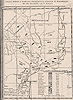 Second, colonial ethnographers stereotyped the Khosa as a model tribe, remarkable among the peoples of southern Mozambique for preserving the power of their chiefs, traditions, and alleged racial purity in the face of Nguni conquest and migrant labor. 76 Missionaries, for instance, wrote with some respect of the intelligence and cultural cohesion they believed were responsible for the strong resistance to Christianity they encountered in Cossine, even while complaining about how hard they had to struggle to win (and hold onto) converts among the Khosa for the very same reason. 77 Second, colonial ethnographers stereotyped the Khosa as a model tribe, remarkable among the peoples of southern Mozambique for preserving the power of their chiefs, traditions, and alleged racial purity in the face of Nguni conquest and migrant labor. 76 Missionaries, for instance, wrote with some respect of the intelligence and cultural cohesion they believed were responsible for the strong resistance to Christianity they encountered in Cossine, even while complaining about how hard they had to struggle to win (and hold onto) converts among the Khosa for the very same reason. 77  the Swiss sought to win souls in part by harnessing women's customary talents as storytellers, educators, healers, and ritual authorities on matters related to birth, marriage, and death. The preservation of indigenous kinship and family structures and, in a Christianized form, the institution of marriage were similarly valued as essential to African social stability; signs of family disintegration—such as rising rates of divorce or premarital pregnancy—caused profound alarm among colonial officials and missionaries. 78 the Swiss sought to win souls in part by harnessing women's customary talents as storytellers, educators, healers, and ritual authorities on matters related to birth, marriage, and death. The preservation of indigenous kinship and family structures and, in a Christianized form, the institution of marriage were similarly valued as essential to African social stability; signs of family disintegration—such as rising rates of divorce or premarital pregnancy—caused profound alarm among colonial officials and missionaries. 78 | ||||||||||||
Yet the strength of Khosa traditions also worried ethnographic mapmakers, and once again their concerns targeted social practices associated with women and behaviors in the realms of sexuality and family life. Missionaries in particular (without, apparently, noticing the irony) mapped indigenous women in terms of their subjugation to polygynous marriage and lovolo (bridewealth), their "immoral" fondness for communal drinking and nocturnal "orgies," and their stubborn insistence on diagnosing illness and misfortune as symptoms of witchcraft. Together with colonial officials, missionaries were also preoccupied with the activities of spirit mediums, the majority of whom were female and whose curative powers gave them a degree of social influence Europeans were never able to undermine or rival. 79 Certain kinds of narrative ethnographic mapping thus depicted Magude as a land notorious for sorcerers who were troublesome in part because they were independent women—a representation that jarred with pictorial and numeric forms of ethnographic cartography that peopled Magude with orderly, patriarchal-lineage homesteads under the unitary authority of traditional chiefs. | 45 | |||||||||||
Finally, the Portuguese colonial state and European settlers mapped Magude as a place rich with potential for economic exploitation and capitalist profit. Colonizers' "profit maps" were in one sense an extension of travelers' cartography, highlighting geographic features that either facilitated or hindered the operations of commerce and locating natural resources that would fetch high prices on the world market. On the other hand, these mappings were also expressions of a struggling colonial economy, often more accurately reflecting European dreams of a tidy racial system of capitalist production and agrarian class relations than the tangled, contested reality that most Africans experienced in the course of everyday life. In Magude, profit maps interpreted climate patterns, geology, groundwater sources, and plant and animal life with an eye to the rich possibilities of commercial farming, hunting, mining, and game preservation. 80 However, in colonizers' eyes, Magude's economic value lay principally in its soils and river networks, and these Portuguese technocrats charted with special care. The earliest of these maps, dating from the late 1890s, consisted of detailed drawings of the Nkomati River and were accompanied by proposals for irrigation schemes whereby white settlers could cultivate such lucrative cash crops as sugar, tobacco, and citrus fruits in the fertile alluvial soils along the river's banks. 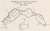 As Portuguese authority spread north and west of the Nkomati, the precarious nature of dryland farming—along with the area's lush grass cover and Africans' own impressive cattle herds—fueled state and settler interest in the development of commercial pastoralism. 81 Both spheres of economic opportunity required formal arrangements through which Europeans could acquire secure property rights to vast tracts of land and thus the introduction to Magude of land surveyors, land "concessions," and systematic cadastral mapping. As Portuguese authority spread north and west of the Nkomati, the precarious nature of dryland farming—along with the area's lush grass cover and Africans' own impressive cattle herds—fueled state and settler interest in the development of commercial pastoralism. 81 Both spheres of economic opportunity required formal arrangements through which Europeans could acquire secure property rights to vast tracts of land and thus the introduction to Magude of land surveyors, land "concessions," and systematic cadastral mapping. | ||||||||||||
Of all types of colonizers' maps, cadastral maps impinged most directly and disruptively on the lives of Africans in Magude; at the same time, they were also the most forcefully opposed form of colonial cartography, especially among communities living farther from the Portuguese government center in Magude town. Administrative subdivisions could draw invisible boundaries on the landscape and decide at which government post people had to pay taxes; censuses, though often half speculation, could claim to know the number, "race," and residential location of everyone under nominal Portuguese authority; ethnographic taxonomies could describe and classify African customs as exhaustively as their authors desired. Over time, these representations of Magude and its inhabitants sometimes took on phenomenological force, helping to shape—though never determining—how Africans defined themselves and their world. But cadastral surveys, by carving the land up into unnaturally straight-edged blocks (first on paper and then, where possible, in the soil itself), assigning (or denying) rights to it in terms of commercial ownership, and buttressing the lines on these maps with the power of state-sanctioned law, sought to transform and appropriate not only control over territorial organization but the land itself—and thus the foundation of Africans' social organization and culture. 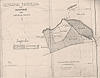 Of the total area of Magude circumscription, more than 90,000 hectares of prime arable and pasture land, including every square inch of the alluvial river plains, had been formally alienated to European settlers or the colonial state by the end of the colonial period. 82 However fanciful—and, in some cases, vigorously opposed—the lines inscribed on survey maps in the colonial cadastral register may initially have been, 83 African residents of Magude came to accept them as legally fixed, and rarely contested the property rights and spread of capitalist agriculture that they signified. Of the total area of Magude circumscription, more than 90,000 hectares of prime arable and pasture land, including every square inch of the alluvial river plains, had been formally alienated to European settlers or the colonial state by the end of the colonial period. 82 However fanciful—and, in some cases, vigorously opposed—the lines inscribed on survey maps in the colonial cadastral register may initially have been, 83 African residents of Magude came to accept them as legally fixed, and rarely contested the property rights and spread of capitalist agriculture that they signified. 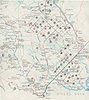 In part, the social power of cadastral maps derived from the "scientific" and purportedly ungendered (because disembodied) quality of their construction, for by concealing their human origins and political objectives in the precisely measured straight lines and quantified areas of their pictorial images, these mappings disavowed the possibility of change or resistance. They portrayed Magude as a place consisting of bounded, "owned" patches of profitable land, "native reserves" set aside for Africans in the most intensely contested areas, and unoccupied spaces—usually still inhabited by Africans, but only because Europeans considered these areas either undesirable or pending future alienation. In part, the social power of cadastral maps derived from the "scientific" and purportedly ungendered (because disembodied) quality of their construction, for by concealing their human origins and political objectives in the precisely measured straight lines and quantified areas of their pictorial images, these mappings disavowed the possibility of change or resistance. They portrayed Magude as a place consisting of bounded, "owned" patches of profitable land, "native reserves" set aside for Africans in the most intensely contested areas, and unoccupied spaces—usually still inhabited by Africans, but only because Europeans considered these areas either undesirable or pending future alienation.
| ||||||||||||
 Academic historians, of course, also use and create maps. That we rarely do so critically means that historians' cartography of Magude is just as propositional as any of the other maps examined in this chapter. In a way, historians' mappings may be even more manipulative, because they are deployed as part of self-consciously interpretive explanations of the past and harness other people's spatial representations, usually without acknowledging the interests that underlie them. However esoteric the scholarly context in which it is produced, academic cartography can wield considerable influence when actors in other domains (e.g., the state, civil society) seek to learn from or take advantage of historians' expert knowledge for their own purposes. Indeed, the political nature of historians' maps is never more apparent than when someone ventures to contradict or revise them or suggests that the silences they contain obscure dissenting points of view. Thus even though the place now known as Magude has had little visibility in the mappings of Mozambican historiography, it has still—by implication—been mapped so thoroughly and convincingly in this literature that I was occasionally asked why I wanted to study a place whose history was already well known to Mozambique scholars. Academic historians, of course, also use and create maps. That we rarely do so critically means that historians' cartography of Magude is just as propositional as any of the other maps examined in this chapter. In a way, historians' mappings may be even more manipulative, because they are deployed as part of self-consciously interpretive explanations of the past and harness other people's spatial representations, usually without acknowledging the interests that underlie them. However esoteric the scholarly context in which it is produced, academic cartography can wield considerable influence when actors in other domains (e.g., the state, civil society) seek to learn from or take advantage of historians' expert knowledge for their own purposes. Indeed, the political nature of historians' maps is never more apparent than when someone ventures to contradict or revise them or suggests that the silences they contain obscure dissenting points of view. Thus even though the place now known as Magude has had little visibility in the mappings of Mozambican historiography, it has still—by implication—been mapped so thoroughly and convincingly in this literature that I was occasionally asked why I wanted to study a place whose history was already well known to Mozambique scholars. | ||||||||||||
Typically, Magude makes a fleeting appearance in scholarly histories of precolonial and colonial southern Mozambique. In the precolonial literature, Magude's status is both crucial and slightly mysterious in each of the three areas of inquiry that have dominated the field so far. In studies of the precolonial trade-and-politics school, historians looking at African chiefdoms near the Nkomati River bend have speculated about their role and power in the valuable overland trade in minerals and ivory between the Transvaal and the Indian Ocean coast. 84 In work on the peopling of southern Mozambique (ironically, an academic version of colonizers' ethnographic cartography, albeit motivated by a different agenda), historians have devoted most of their attention to the "puzzle" of Tsonga origins, in the process sketching the Magude area—both narratively and in pictorial maps emblazoned with bold arrows symbolizing each people's trajectory of migration and settlement 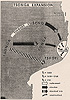 —as a place of dynamic population movement, ethnogenesis, and ethnic change. 85 Troubled, however, by the inconsistencies in oral traditions about the precise origins and timing of group migrations and by the dearth of supplementary archaeological research to verify oral claims, historians have tended to hedge their conclusions for this area with expressions of uncertainty and provisional truth, and at no point have they pursued such intriguing questions about migration and intermarriage as why so many newcomers to the area (e.g., Sotho-speaking Pedi groups circa 1700) "abandoned their . . . customs and language, married local women, and became 'true Tsonga.'" 86 —as a place of dynamic population movement, ethnogenesis, and ethnic change. 85 Troubled, however, by the inconsistencies in oral traditions about the precise origins and timing of group migrations and by the dearth of supplementary archaeological research to verify oral claims, historians have tended to hedge their conclusions for this area with expressions of uncertainty and provisional truth, and at no point have they pursued such intriguing questions about migration and intermarriage as why so many newcomers to the area (e.g., Sotho-speaking Pedi groups circa 1700) "abandoned their . . . customs and language, married local women, and became 'true Tsonga.'" 86 | ||||||||||||
In writing on the Gaza Nguni state, scholars have similarly fudged their stories where Magude is concerned, unsure of the exact nature of Khoseni's relationship to the slave- and tribute-taking polity and reluctant—particularly within the narrative of heroic resistance to Portuguese conquest, in which Ngungunyana leads a courageous battle to defend African sovereignty—to tackle the issue of widespread popular resentment of Gaza rulers or of the active opposition to Ngungunyana on the part of some local chiefs. 87 Indeed, documentary sources suggest that the political relationship between Magude-area leaders and Nguni rulers fluctuated fairly dramatically throughout the nineteenth century. In 1856, according to Swiss missionary-ethnographer Henri A. Junod, the Nguni leader Soshangane launched a military expedition against the Khosa, Rikhotso, and Baloyi chiefs (all within the present boundaries of Magude district) because they, apparently under João Albasini's influence, wished to switch their allegiance to Dutch-descended settlers in the Transvaal. 88 After Manukosi's death, however (as noted above), Chief Magudzu Khosa lent critical military and diplomatic support to Mzila in his struggle against his brother Mawewe in the Gaza succession war of 1858-62, and Magudzu seems to have been regarded more as an ally than as a vassal of the Nguni state. 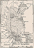 Yet when Ngungunyana assumed power after Mzila's death in 1884, relations with Khosa leaders appear to have soured as Gaza armies became increasingly rapacious, and Xongela's decision to sign a treaty of vassalage with the Portuguese in 1895 was clearly guided by a desire to secure some measure of political autonomy through protection from Ngungunyana's European rivals. Although the belated anticolonial revolt of Maguiguana Khosa and his assassination within present-day Magude seem to have reassured scholars of the area's ultimate loyalty—or subordination—to the Gaza state, visual maps of the geographic extent of Gaza suzerainty still leave considerable room for interpretation about the status of the powerful Khosa polity and Magude-area inhabitants vis-à-vis Nguni rule. Yet when Ngungunyana assumed power after Mzila's death in 1884, relations with Khosa leaders appear to have soured as Gaza armies became increasingly rapacious, and Xongela's decision to sign a treaty of vassalage with the Portuguese in 1895 was clearly guided by a desire to secure some measure of political autonomy through protection from Ngungunyana's European rivals. Although the belated anticolonial revolt of Maguiguana Khosa and his assassination within present-day Magude seem to have reassured scholars of the area's ultimate loyalty—or subordination—to the Gaza state, visual maps of the geographic extent of Gaza suzerainty still leave considerable room for interpretation about the status of the powerful Khosa polity and Magude-area inhabitants vis-à-vis Nguni rule. | 50 | |||||||||||
References to Magude also occasionally surface in scholarship on colonial Mozambique as a whole, whether as one of many sites where peasants burned cotton seed to avoid the onerous demands of forced cotton production 89 or as one of many sources of chibalo (forced labor) when economic depression, ecological crisis, and a drop in recruitment levels for the South African mines created a surplus of men who, according to Portuguese definitions, were idle—i.e., could be rounded up to work for private or public European concerns. 90 Writing on colonial southern Mozambique in particular has long been dominated by studies of male migrant labor, and the exploitation and underdevelopment of African peasants in the Sul do Save by the fiscally impoverished Portuguese colonial state in alliance with South African mining capital. 91 This literature devotes most of its investigative effort to migrants' destinations (the mines, factories, and plantations across the border), and it subsumes Magude—along with the rest of the populations south of the Save River—as a reserve of oscillating male migrant workers, whose long-term absences from the countryside are said to leave rural communities emasculated (in demographic, economic, and social terms) and inadequately maintained by struggling households headed by the women "left behind." In this sense, and at the broadest level of generalization, Magude as part of the Sul do Save is implicitly homogenized in historical arguments about processes of economic differentiation, cash dependence, and rural decline across the entire labor-exporting region of southern Africa. | ||||||||||||
Even when scholars highlight the ways in which "the origins of migrant labour were . . . rooted in processes and relationships"—including gender relations—"that were largely internal to the labour-exporting societies" and urge researchers both to historicize the gendered patterns of labor migrancy and to recognize women's "creative agency" in developing "new family forms" in its shadow, 92 gender-sensitive explanations have still tended to represent the lot of rural women throughout the region in a uniform way: as wives and mothers who suffer the impact of a system whose construction and functioning have nothing to do with them. 93 Basing its conclusions largely on the writings of colonial anthropologists from the 1920s on, this work reports such trends as rising rates of divorce, adultery, pre- or extramarital pregnancy, generational conflict, and the breakdown of sexual morality and indigenous social institutions and relationships—viewing the latter, ironically, as both tragedy and potential boon for women who are presumed to have been uniformly oppressed in traditional society. Unfortunately, the argument goes, "the migrant labor system . . . undermined existing systems of social organization, [yet] prevented the organic development of alternatives," so that rural women were "transferred from one system of subordination to another"—from "patriarchal" relations of production within traditional homesteads to the market-based relations of the colonial-capitalist state. 94 That the women themselves might see things another way, might construe changing marriage and family arrangements in a more positive light, or might be so busy forging affective communities of other kinds that they did not view shifts in marriage or motherhood patterns in apocalyptic terms—these are not questions that the region's scholars have felt compelled to ask, and indeed they have sometimes been explicitly dismissed as naïve and romantic. 95 | ||||||||||||
Within this reductionist political-economy mapping of the region, Magude emerges as slightly exceptional for two reasons: its early exposure to mission Christianity, to which historians attribute the higher degree of commercial development and peasant prosperity evident there by the late colonial period, and its location on one of the major overland migration routes and along a weakly controlled section of the international border where thousands of clandestine labor migrants crossed every year. 96 Because the Swiss at Antioka were more prolific and organized in their record-keeping than were the Portuguese, historians have had access to a rich body of written material through which to explore certain aspects of the area's history. So far, however, these records have been tapped primarily to understand the origins of male labor migrancy and its impact on the rural economy, and there has been little effort to problematize the testimony of men and women who were preoccupied, on the one hand, with distinguishing themselves from their "brutish" Portuguese colleagues and, on the other hand, with proving their determination to overcome Africans' "moral degeneracy" and spiritual "backwardness." The Swiss, believing that a life of migrancy only worsened an already deplorable set of cultural values and social practices, struggled to dissuade rural men from devoting themselves to it. Given that, we should not be surprised that scholars involved in migrant-labor historiography and in the limited work dealing with women and agrarian change in southern Mozambique interpret women's agricultural innovations, changing gender and family dynamics, and ritual initiatives related to the land either as evidence of women's suffering or as forms of female coping with migrancy-induced social crisis. 97 Here, we see rural women not only left behind but forced to stay behind, chained to their marital home "to ensure the productive and reproductive base of the domestic economy that provided migrants with a second source of accumulation, as well as a refuge in times of trouble." 98
| ||||||||||||
Frelimo's final wringing of independence from Portugal, the sixteen-year horror of the Renamo war, and most recently the internationally brokered (and financed) restoration of "peace" are the three defining events in Mozambique's career as a nation since 1975.  All have been painful and conflict-ridden; all have been analyzed in ways that insist on the determining power of governments, economies, and ideas beyond Mozambique's borders to shape—or destroy—the lives of the individuals within. Understanding mappings of Magude in the context of two decades of such tumultuous changes is a proportionally more complex task, as both the spatial representations and the constructed boundaries of previous centuries have been blasted apart in an unprecedented way, and were still, in 1995-96, in the process of what the Frelimo government and its international backers optimistically called reconstruction. But Magude has shared in the drama of postindependence events in a manner uniquely embedded in its past, and has been represented by the diverse powers at play in the young nation through mappings with potentially greater real-life implications for the district's inhabitants than ever. All have been painful and conflict-ridden; all have been analyzed in ways that insist on the determining power of governments, economies, and ideas beyond Mozambique's borders to shape—or destroy—the lives of the individuals within. Understanding mappings of Magude in the context of two decades of such tumultuous changes is a proportionally more complex task, as both the spatial representations and the constructed boundaries of previous centuries have been blasted apart in an unprecedented way, and were still, in 1995-96, in the process of what the Frelimo government and its international backers optimistically called reconstruction. But Magude has shared in the drama of postindependence events in a manner uniquely embedded in its past, and has been represented by the diverse powers at play in the young nation through mappings with potentially greater real-life implications for the district's inhabitants than ever. | ||||||||||||
While Magude was not one of the highest-priority areas in Frelimo's planned socialist transformation of the countryside, it was nonetheless a district whose relative prosperity and proven potential for commercial livestock and irrigated cash-crop production earned it a respectable standing in the new government's development scheme. The most valuable land concessions abandoned by Portuguese settlers were grouped together to form two state enterprises, one for agriculture and one for cattle, and several agricultural producer and consumer cooperatives (including the country's pioneering co-op, named after Maguiguana) were established in and around Magude town in the late 1970s. In addition, health posts, schools, and "people's farms" were opened at various sites in the district, and the national women's organization (Organização de Mulheres Moçambicanas, or OMM) opened branches and appointed a secretary for the district and delegates for each of Magude's five new administrative posts. 99 Ironically, although Frelimo attacked all elements of traditional culture as "feudal" and "obscurantist" and valued Magude in part because its longstanding connection with the Swiss Mission had allegedly enlightened at least some of its inhabitants, 100 the area was still renowned for its many powerful diviners and spirit mediums and for the resilience of chiefly authority and rain sacrifices especially in communities near the border. Thus the district was also targeted by the Ministry of Culture in its campaign to collect remnants of Mozambique's cultural patrimony in the form of oral traditions and descriptions of old customs—particularly anything associated with the prestigious Khosa clan. 101 In other words, within the context of postcolonial nation-building and fledgling national socialism, Frelimo mapped Magude in terms of both hope for the future and pride in the indigenous past—even while it set about with ideological ferocity to eradicate the actual practice of tradition from people's everyday lives in the present. | 55 | |||||||||||
The tragedies of the Mozambican war have been well documented and analyzed, as have the complex external and internal conflicts that undermined Frelimo's ambitious experiment with state-driven socialism. 102 Although academic and foreign media reports consistently represented southern Mozambique as a Frelimo stronghold during the war, Magude was in fact a battleground between government and Renamo forces from the mid-1980s until well after the formal end of the fighting in 1992. 103 In Magude, as in the center and north of the country, Renamo guerrillas concentrated their most violent attacks on symbols of state "improvements" (collective farms, schools, health posts), and on former properties of the Swiss Mission (nationalized at independence) as a way of exacting revenge for missionaries' assistance to Frelimo during the liberation struggle. However, Renamo gained ground in more remote parts of the district as it played on popular grievances related to hunger, caused by a combination of prolonged drought and commercial collapse, and, perhaps especially, by fuelling resentment of Frelimo's assault on cultural traditions. Renamo soldiers' own very public reliance on spirit mediums in Magude helped to convince all but the most devout Christians that the rebels were more in touch with the people than were Frelimo politicians in the capital city, with their grand theories of social change and contempt for the ways of the ancestors. | ||||||||||||
Moreover, the sparsely populated, hilly border area of the district had a special strategic importance because of Renamo's dependence on logistical support from South Africa. The rebels established a major base in southwest Magude (extending south into Moamba district) in 1986. Known as Ngungwe, after the river beside which they built their camp, this base served as a holding ground for the hundreds of captives (mainly women and children) and thousands of cattle Renamo drove from across southern Mozambique in the later years of the war. Government forces mounted an intense air attack on Ngungwe in the late 1980s, and in the ensuing ground battle Renamo troops burned a tank full of Frelimo soldiers, creating government martyrs for which this place is now locally both notorious and sacred.  The fact that Renamo took over Magude's two western administrative posts and held them until mid-1995 (Renamo ex-combantants were still occupying Ngungwe when I left in late 1996, although they had taken their flag down) reinforced the impression in official circles that the district, or at least that part of it under Renamo influence, had reverted to the dangerous and wild condition of its frontier past. 104 The fact that Renamo took over Magude's two western administrative posts and held them until mid-1995 (Renamo ex-combantants were still occupying Ngungwe when I left in late 1996, although they had taken their flag down) reinforced the impression in official circles that the district, or at least that part of it under Renamo influence, had reverted to the dangerous and wild condition of its frontier past. 104 | ||||||||||||
This wartime mapping of Magude had profound consequences for developments in the district after the end of the war. While officials of the United Nations High Commission for Refugees boasted of their successful refugee repatriation program in Mozambique, and the international community (led by the United States and the World Bank-IMF alliance) held the country up as a model of postsocialist democratization and economic restructuring, Magude remained an exceptional, troubled place, the one district in the south to which refugees were, at first, extremely reluctant to return, and where foreign and domestic NGOs, as late as 1995-96, were still unusually hesitant about sending personnel and investing resources. 105 People speaking from various official positions in postwar society cited a range of reasons for these trends, all distillable into the same refractory image of Magude as a land of contradictions and potentially mortal—again, often feminine—peril: The district had been reclaimed by the bush and wild animals; there were too many buried landmines, roving bandits, and illegal weapons in circulation; 106 rural communities were ruled by witches and spirit mediums, while the town was full of prostitutes who corrupted young men and ruined marriages. In fact, as late as October 1996, so uncertain of Magude's postwar loyalty was the Mozambican government that President Joaquim Chissano made a special tour through the district and gave a much publicized speech in Phadjane, a place especially infamous for its witches. He promised a skeptical and restless audience that Frelimo had become an ardent supporter of tradition, intended to rehabilitate traditional chiefs, and would generously subsidize cattle and seed distribution to revive the district's once flourishing agrarian economy. What he did not tell people, however, was that his government, under the urging of the World Bank, had another plan for Magude, one disturbingly consistent with the district's nineteenth-century image as a place unsuited for human habitation: an enormous nature reserve that would run the length of its western border (as a Mozambican extension of South Africa's Kruger Park), encompassing more than 100,000 hectares of historically sacred sites in the Lebombo hills, the prime pasture of the adjoining lowlands, and the ancestral homes of thousands of Magude refugees still in the Transvaal. 107
| ||||||||||||
 Obviously, I too am actively (and partially) involved in the mapping of Magude and, like the other maps I have discussed in this chapter, mine too developed and changed over time. My first impressions of the district came from individuals speaking from their positions in Maputo as rebuilders of a decimated postcolonial state: government officials, NGO personnel, UN demining teams, and expatriate partisans of Frelimo's outdated socialist cause. Uniformly, they portrayed Magude as a place containing nothing of importance for a historian to study and too unsafe for me to consider living there in any case. When such people learned that I was particularly interested in interviewing rural women, their skepticism usually deepened, or else they would offer what they believed were words of encouragement by assuring me that at least the few remaining elderly women in the countryside might teach me something about old customs. Such comments are maps too, not only because they reinforce stereotypes of this area as inaccessible to white outsiders (particularly female ones), and not only because they construct Magude as simultaneously lacking history and possessing women (atavistic and outside history themselves) whose knowledge of the past is limited to a timeless inventory of quaint beliefs and practices. Such comments are also, and perhaps most powerfully, maps because they de-people—indeed, sweep clean—Magude's physical landscape, thus sanctioning their own plans for the development of the district. Obviously, I too am actively (and partially) involved in the mapping of Magude and, like the other maps I have discussed in this chapter, mine too developed and changed over time. My first impressions of the district came from individuals speaking from their positions in Maputo as rebuilders of a decimated postcolonial state: government officials, NGO personnel, UN demining teams, and expatriate partisans of Frelimo's outdated socialist cause. Uniformly, they portrayed Magude as a place containing nothing of importance for a historian to study and too unsafe for me to consider living there in any case. When such people learned that I was particularly interested in interviewing rural women, their skepticism usually deepened, or else they would offer what they believed were words of encouragement by assuring me that at least the few remaining elderly women in the countryside might teach me something about old customs. Such comments are maps too, not only because they reinforce stereotypes of this area as inaccessible to white outsiders (particularly female ones), and not only because they construct Magude as simultaneously lacking history and possessing women (atavistic and outside history themselves) whose knowledge of the past is limited to a timeless inventory of quaint beliefs and practices. Such comments are also, and perhaps most powerfully, maps because they de-people—indeed, sweep clean—Magude's physical landscape, thus sanctioning their own plans for the development of the district. 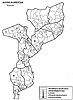 In the early postwar era of Mozambique's economic dismemberment and recolonization 108 at the hands of the Western aid community, Magude's territorial identity increasingly acquired new national and international dimensions—a phenomenon that is graphically illustrated in the proliferation of stylized, computer-generated maps that constitute the district (along with the rest of the country) in terms of refugee-return rates, food aid, landmines, demobilized soldiers, and the like. Revealingly, on many if not most of these new maps, Magude is one of the districts frequently left blank because of "insufficient information." In the early postwar era of Mozambique's economic dismemberment and recolonization 108 at the hands of the Western aid community, Magude's territorial identity increasingly acquired new national and international dimensions—a phenomenon that is graphically illustrated in the proliferation of stylized, computer-generated maps that constitute the district (along with the rest of the country) in terms of refugee-return rates, food aid, landmines, demobilized soldiers, and the like. Revealingly, on many if not most of these new maps, Magude is one of the districts frequently left blank because of "insufficient information." | ||||||||||||
When I finally reached Magude, I was quickly bombarded with mappings of a rather different kind, from local men who were in various positions of authority and had their own views on how I should conduct historical research in the district. António Joaquim Cebola, the district administrator at the time, nodded sagaciously while I explained my project, sanctioning it because, he said, "It is very important to study how women peasants have suffered because of long separations from their husbands." 109 A senior male member of a prominent chiefly family presented himself to me as the vice president of the Magude branch of the Organização das Autoridades Tradicionais de Moçambique (Organization of Mozambican Traditional Authorities), eagerly hinting that he should be interviewed because he was involved in local discussions about the rehabilitation of traditional leaders and customs. And the young, Maputo-raised pastor of the struggling church at Antioka volunteered to introduce me to the elders who, he assured me, were most knowledgeable about local history: three men and one woman, all of whom lived on or adjacent to the church property and were lifelong Christians central to the collective biography of the congregation. Although all four greeted us warmly, the men displayed far greater interest in my research and launched immediately into reminiscences they believed were essential to my understanding of their pasts, reminiscences concerned primarily with the heroism of Ngungunyana, Portuguese colonial abuses, their experiences of wage work, and above all their personal connections (and deep gratitude) to the Swiss missionaries. Each man also proudly and pointedly told me the date of his birth. The woman, on the other hand, a childless widow who had grown up virtually a ward of the Swiss, became somewhat diffident—almost coy—when the pastor broached the reason for our visit, laughing off his attempt to determine her age and suggesting that if I wanted to know about history I should talk to "Papa" Sinai, one of the three men we had already visited. | 60 | |||||||||||
As positionings of Magude, these first responses to my presence hinted at yet another layer of mappings complicating my quest to understand rural women's histories. The individuals—government figures, traditional elites, influential church members— who claimed to be authoritative sources of knowledge about the past were all men. Although each had his own agenda structuring what he wished to tell me about Magude's history, their representations shared certain basic preoccupations: with formal politics (whether of Gaza rulers, local chiefs, or the state), the common xilungu (whitish) cultural grounds between myself and them (i.e., literacy, Christianity), and the embeddedness of their lives in a commercialized, wage economy dependent on South Africa. These topics were narrative gateways to what these men considered important knowledge about their history and the history of Magude, and the gendered character of this knowledge was demonstrated most clearly when the one female authority to whom the pastor introduced me smilingly refused to furnish the information we requested, insisting she did not know anything about such matters. | ||||||||||||
Subsequent interviews with nonelite men reinforced my sense that local mappings of Magude's history were profoundly gendered and that the view that women had little of importance to say about the past was widespread even here. But I also came to appreciate the complex ways in which men's mappings in turn diverged according to age, class, education, work history, clan and ethnic identity, and individual experiences of the war. Men who were still displaced, for instance, spoke urgently and at great length about clan traditions of migration to and settlement in the land from which Renamo's forces had driven them. One very old man, Caissene Mundlovu, who had fled from his rural homestead in 1987 and was still living in the crowded deslocado settlement of Matendeni in Magude town when I met him in 1995, insisted that I hire a truck to drive us more than a hundred kilometers to what was then a barely accessible spot where he had lived before the war, in the extreme northwest of Magude district. He wanted to show me what he considered the most precious of historical places: a rocky bend in the N'wanetsi River where, before the arrival of the Portuguese, women used to go to gather salt; a nearby cave full of bees that was once a closely guarded source of honey; and a secret burial ground where his ancestors, after migrating from the Transvaal in the mid-nineteenth century, had stored hand-forged iron hoes from Phalaborwa (Vecha) that were so valuable a man needed only one to lovola (give bridewealth for) a wife. 110 | ||||||||||||
As distant as this elderly deslocado's historical concerns seem from those of more powerful men, they share core themes that were specific to masculine constructions of the past—and of Magude—that I encountered during fieldwork. Possibly the oldest surviving male of the ruling family in that corner of the district, anxious about both his responsibilities as caretaker of clan history and his inability to return home after the end of the war, Caissene mapped Magude's past for me in terms of ancestral-lineage ties with the Transvaal, the gendered political economy of traditional marriage, and, perhaps above all, memories of agrarian self-sufficiency securely anchored to geographic place. Like the men mentioned above, he was most eager to tell me stories that assumed male political authority, economic responsibility, and social control. For him as for the others, Magude was a meaningful entity to the extent that it was constituted by the claims and actions of men who officially wielded these forms of power: from chiefs, soldiers, and administrators to missionaries, migrant workers, and patrilineage and clan heads. The fact that the details of men's memories varied is less significant, I think, than their gender-specific character and men's keen conviction that it was on these discursive terrains that tellings of history should take place. | ||||||||||||
One incident provided an especially poignant illustration. During an interview trip to the same part of the district that I visited with Caissene, Ruti and I happened upon a group of older men engaged in a heated discussion around a pot of beer. When we greeted them, one of the men challenged Ruti to tell him the origin (ntumbuluko) of her clan—where they came from and how they arrived at the place they inhabit today. Ruti (just as challengingly) recited the information he was looking for, but then acknowledged with a laugh that his test was justified because, as she put it, "No one knows these things anymore." Pleased with her answer, the men responded in a chorus of complaint about younger generations' ignorance of their clan histories. One man's observation summed up the feelings of the group: "No one knows where they come from now. Our children don't even know where the land [tiko] of their clan is! It's the war. It's because of the war, everyone scattered to different places. Now all people know is whether they're 'Frelimo' or 'Renamo.'" 111 Ruti later confirmed what I had already begun to observe in our interviews: that this concern about the disappearance of knowledge of territorial identity—and the reconstitution of identity in terms of the place-less vagaries of party politics—was peculiar to men in Magude and a topic of constant conversation among them. Not once in all the time I spent in the district did I witness a woman articulate similar anxiousness about, or even interest in, this matter. | ||||||||||||
I do not mean to exaggerate or essentialize the difference, now or in the past, between men's and women's understandings of place in this corner of southern Africa. Indeed, as I argue in the following chapter, gendered spatial identities are integrally related to gendered ways of remembering Magude's past, and the two are inseparably woven into, and produced through, processes of social and material change. Moreover, in a variety of ways, men's postwar mappings of the district—like those I encountered in the capital city and the others explored above—influenced how women in Magude were lending spatial order to their own memories. Yet gender differences in Magude's various mappings are real, and, as the remaining chapters in this study demonstrate, the boundaries and place-meanings constructed by European travelers, Portuguese colonizers, Western academics, postindependence reformers, and local men—the sources of official interpretations of Magude's history so far—have never enjoyed as much hegemony as they have implicitly claimed over women's lives. Anne McClintock's assertion, quoted at the head of this chapter, that because colonized African women became "the space on which male contests [were] waged," they "experience particular difficulties laying claim to alternative genealogies and alternative narratives of origin and naming," only holds true for women in Magude if we retain (as she does) the evidentiary starting points that have dominated the historiography so far. 112 But the women I knew tended to conceptualize their historical landscapes in ways that resulted in mappings distinctly different from those examined in this chapter—not only because the label Magude had little material meaning for them but because Magude, like other discursive shapings of their world that have been imposed on them by someone else, did claim to reduce and subordinate their identities, genealogies, and histories to interests not necessarily coincident with their own. In chapter 2, I pursue the question of mapping feminine histories by exploring how women in Magude have used various kinds of naming practices to negotiate their own place in the past. Through this form of historical remembering, we can begin (as I did, quite literally) to trace the contours of community and change that women in Magude have recorded and struggled to pass on from one generation to the next, even—in fact, especially—under the extraordinarily difficult circumstances of the postwar world. | 65 | |||||||||||
| Notes: Note 1: The recognition that "women have different spaces, mapped on different grids than men" has driven research in feminist geography since the mid-1980s. See Gillian Rose, "On Being Ambivalent: Women and Feminism in Geography," in New Words, New Worlds: Reconceptualising Social and Cultural Geography: Proceedings of a Conference in the Department of Geography, University of Edinburgh, ed. C. Philo (Lampeter: St. David's University College, 1991), 160. For an example of feminist cartography, see Catherine Nash, "Remapping the Body/Land: New Cartographies of Identity, Gender, and Landscape in Ireland," in Writing Women and Space: Colonial and Postcolonial Geographies, ed. A. Blunt and G. Rose (New York: Guilford Press, 1994). Back. Note 2: Soshangane, one of the Ndwandwe-Nguni warlords who migrated northward to escape Shaka's Zulu armies during the mfecane (c. 1820), founded a powerful centralized state in the area of present-day southern Mozambique. The direct authority of this state, known as the Gaza kingdom, eventually extended over all of the lands south of the Limpopo River (except for the coastal settlements at Inhambane and Lourenço Marques) and into the northern Transvaal and eastern Zimbabwe. Indirect Gaza control, through tribute-paying arrangements with local rulers, extended farther north to the Zambezi River. After a prolonged and devastating succession war between Soshangane's sons Mzila and Mawewe (1858-62), the victorious Mzila ruled the Gaza kingdom during the period of its greatest territorial expansion; he was succeeded by his son Ngungunyana in 1884. Ngungunyana held power until his defeat and capture by the Portuguese in 1895. See Malyn Newitt, A History of Mozambique (Johannesburg: Witwatersrand University Press, 1995), 256-62, 295-97, 348-52. Back. Note 3: In The Power of Maps (New York: Guilford Press, 1992), Dennis Wood distinguishes between "mapping" and "map-making" (or "map-immersed") societies, arguing that cartography developed along with the state "as an instrument of polity, to assess taxes, wage war, facilitate communications and exploit strategic resources" (43). Here Wood follows Brian Harley, who in turn drew on social theorists such as Michel Foucault and Anthony Giddens to "deconstruct" cartography as "a form of political discourse concerned with the acquisition and maintenance of power," specifically the power of the state (Brian Harley, "Silences and Secrecy: The Hidden Agenda of Cartography in Early Modern Europe," Imago Mundi 40 [1988]: 57-76). The literature on this subject is extensive and growing. See also J. B. Harley, "Deconstructing the Map," Cartographica 26 (1989): 1-20; Jeremy Black, Maps and Politics (Chicago: University of Chicago Press, 1997); Mark Warhus, Another America: Native American Maps and the History of Our Land (New York: St. Martin's Press, 1997). For an example from Africa, see Thomas J. Bassett and Philip W. Porter, "'From the Best Authorities': The Mountains of Kong in the Cartography of West Africa," JAH 32, no. 3 (1991): 367-413. Back. Note 4: A core tenet of feminist geography, like feminist social science more generally, is a critique of the Cartesian epistemology of disembodied knowledge and the rhetoric of scientific objectivity, which masks the situated and subjective character of all knowledge. See Kathleen M. Kirby, "Re:Mapping Subjectivity: Cartographic Vision and the Limits of Politics," in BodySpace: Destabilizing Geographies of Gender and Sexuality, ed. Nancy Duncan (London: Routledge, 1996). Back. Note 5: For an example from contemporary Dar es Salaam, where gender functions along with a range of other social factors to shape people's notions of self, community and space, see Richa Nagar, "Exploring Methodological Borderlands through Oral Narratives," in Thresholds in Feminist Geography: Difference, Methodology, and Representation, ed. John Paul Jones III, Heidi J. Nast, and Susan M. Roberts (Lanham, Md: Rowman and Littlefield, 1997). Back. Note 6: J. B. Harley, "Maps, Knowledge, and Power," in The New Nature of Maps: Essays in the History of Cartography, J. B. Harley and Paul Laxton (Baltimore: Johns Hopkins University Press, 2001), 278. Back. Note 7: Cf. Jeanne Kay, "Landscapes of Women and Men: Rethinking the Regional Historical Geography of the United States and Canada," Journal of Historical Geography 17, no. 4 (1991): 435-52. Back. Note 8: This term is from Harley, "Maps, Knowledge, and Power," 285. Back. Note 9: Henri Breuil and Clarence van Riet Lowe, The First Impressions of an Archaeological Tour of the Southern Extremity of the Colony of Mozambique (Lourenço Marques: Comissão de Monumentos e Relíquias Históricas de Moçambique, 1944), 14. For reports on the original discovery, see L. A. Barradas, "Uma Estação Paleolítica em Magude," BSEM 45, no. 11 (1942): 83-101; and Alexandre Borges, Geologia e pre-história de Magude (Lourenço Marques: Imprensa Nacional de Moçambique, 1945). Back. Note 10: Lowe and Breuil, 16. Back. Note 11: João Morais, "Mozambican Archaeology: Past and Present," African Archaeological Review 2 (1984): 113-28. Back. Note 12: Barradas, 99-100. Back. Note 13: Lowe and Breuil, 13, 16-17. Back. Note 14: Here I am applying insights from feminist archaeology, as in "Original Narratives: The Political Economy of Gender in Archaeology," by Margaret W. Conkey, in Gender at the Crossroads of Knowledge: Feminist Anthropology in the Postmodern Era, ed. M. di Leonardo (Berkeley: University of California Press, 1991); see also Joan M. Gero, "Genderlithics: Women's Roles in Stone Tool Production," in Engendering Archaeology: Women and Prehistory, ed. Joan M. Gero and Margaret W. Conkey (Oxford: B. Blackwell, 1991); and Janet D. Spector, What This Awl Means: Feminist Archaeology at a Wahpeton Dakota Village (St. Paul: Minnesota Historical Society Press, 1993). Back. Note 15: For discussions of the new agenda, see "Digging Up the Past in Mozambique," Africa 102 (1980): 56-57; Morais, "Mozambican Archaeology: Past and Present"; Paul J. J. Sinclair, "Archaeology, Ideology, and Development: Mozambican Perspectives," Archaeological Review from Cambridge 5, no. 1 (1986): 77-87. Back. Note 16: The pioneering work within this paradigm is João Morais, The Early Farming Communities of Southern Mozambique (Studies in African Archaeology 3, Eduardo Mondlane University, Mozambique and Central Board of National Antiquities, Sweden, 1988). Back. Note 17: An important archaeological reinterpretation of precolonial southern African history is contained in Farmers, Kings, and Traders: The People of Southern Africa, 200-1860, by Martin Hall (Chicago: University of Chicago Press, 1990). For an overview of regional research, see Tim Maggs and Gavin Whitelaw, "A Review of Recent Archaeological Research on Food-Producing Communities in Southern Africa," JAH 32, no. 1 (1991): 3-24. The issue of a regional research agenda was discussed at the 10th Congress of the PanAfrican Association for Prehistory and Related Studies, held in Harare, Zimbabwe, 18-23 June 1995. Back. Note 18: Ricardo T. Duarte, "Three Iron Age Sites in Massingir Area, Gaza Province, Moçambique and Their Importance in the Southern Moçambique Bantu Settlement," in Iron Age Research in Mozambique, ed. M. L. T. Duarte, T. Cruz e Silva, J. C. de Senna Martinez, J. Morais, and R. T. Duarte (Maputo: Instituto de Investigação Científica de Moçambique, 1976), 18. Back. Note 19: Cf. Rita P. Wright, "Women's Labour and Pottery Production in Prehistory," in Engendering Archaeology, ed. Gero and Conkey. Back. Note 20: Hall, Farmers, Kings, and Traders, 71. Back. Note 21: Gerhard Liesegang, "Historical Continuity and Ceramic Change: A Note on Wares Used by the Gaza Nguni in the Nineteenth Century," South African Archaeological Bulletin 29 (1971): 60-64. Back. Note 22: See, for example, Philip D. Curtin, The Image of Africa: British Ideas and Action, 1780-1850 (Madison: University of Wisconsin Press, 1964), vol. 1, chap. 8; and Jean and John Comaroff, Of Revelation and Revolution: Christianity, Colonialism, and Consciousness in South Africa (Chicago: University of Chicago Press, 1991), 86-97. Back. Note 23: Anne McClintock, Imperial Leather: Race, Gender, and Sexuality in the Colonial Conquest (New York: Routledge, 1995), 27-28. See also Harley, "Maps, Knowledge, and Power," 279-83; and Jeffrey C. Stone, "Imperialism, Colonialism, and Cartography," Transactions of the Institute of British Geographers 13 (1988): 57-64. Stone makes an important distinction between imperial and colonial mapping with respect to the former's preoccupation with scientific accuracy and "instrumentally-derived precision" (59) in charting Africa's physical landscape. Changes in the cartography of Magude between the nineteenth and twentieth centuries confirm Stone's point, as I discuss below. Back. Note 24: Cf. Mary Louise Pratt, Imperial Eyes: Travel Writing and Transculturation (New York: Routledge, 1992). An extreme example of the fictional quality of travelers' narratives is St. Vincent Erskine's widely cited report, "Journey to Umzila's, South-East Africa, in 1871-1872" (JRGS, 45 [1875]), which he candidly admits is "composed entirely from memory," as all his notebooks from this expedition were lost in a river crossing (45). Back. Note 25: For European "myth and speculation" about the late sixteenth-century Monomotapa empire on the northern part of the Zimbabwe plateau and for possible links of the Motapa state to Great Zimbabwe, see Newitt, History of Mozambique, 38ff.; and David Beach, The Shona and Zimbabwe, 900-1850: An Outline of Shona History (New York: Africana pub. co.,1980). Back. Note 26: Alan K. Smith, "The Struggle for Control of Southern Mozambique, 1720-1835" (Ph.D. diss., UCLA, 1970), 36-38. Back. Note 27: Manuel de Mesquita Perestrello, "Narrative of the Wreck of the Ship St. Benedict," in Records of South-Eastern Africa, ed. G. M. Theal, (Cape Town: C. Struik, 1964), 1:267. For summaries of Portuguese reports on this and three other shipwrecks along the southern Mozambican and Natal coast in the sixteenth century, see Henri A. Junod, "The Conditions of the Natives of South-East Africa in the Sixteenth Century, According to the Early Portuguese Documents," South African Journal of Science 10 (1913): 137-61. Back. Note 28: Smith, 63-66; Gerhard Liesegang, "Lourenço Marques antes de 1895: Aspectos da história dos estados vizinhos, da interacção entre a povoação e aqueles estados e do comércio na baia e na povoação," Arquivo 2 (1987): 19-75. For translations of key Dutch accounts, see Gerhard Liesegang, "New Light on Venda Traditions: Mahumane's Accounts of 1730," History in Africa 4 (1977): 163-81; J. van de Capelle, "Relação (sobre Delagoa Bay), 1723," Moçambique: Documentário Trimestral 30 (1942): 7-30; I. Monna and L. Spruit, "Relatório e diário, mantido por nos, abaixo assinados, por instrução do Illmo Senhor Jan van de Capelle, Chefe Local Interino, na Lancha 'de Hoop,' navegando e examinando o rio do norte desta baia, ou de St. Esprit, assim como para descobrir tudo que possível da cidade ou do império Monomotapa, bem como de Simbãos, etc., etc., a saber (1728)," Moçambique: Documentário Trimestral 32 (1943): 11-29. Back. Note 29: Smith, 321; Francisco de Santa Thereza, "Plano e relação da Bahia, denominada de Lourenço Marques, na costa de Natal ao norte do Cabo da Boa Esperança, junto ao promotório da latitude de 26 grãos, e não menos das terras adjacentes, seus habitadores, reys, rios, comércio, costumes (1784)," in Caetano Montez, Descobrimento e fundação de Lourenço Marques, 1500-1800 (Lourenço Marques: Minerva Central, 1948), 168. Back. Note 30: Slave exports from Mozambique were prohibited in 1836, and in the 1840s Portugal agreed to let British ships enter Mozambican rivers and harbors and search vessels suspected of continuing an illicit trade in African slaves. According to Patrick Harries, however, these measures simply drove some slavers farther north and, until the 1870s, did not prevent a profitable trade in slaves or, later, engagé labor purchased for markets in Brazil, Cuba, Réunion, and Natal from being conducted at Lourenço Marques (Patrick Harries, "Slavery, Social Incorporation, and Surplus Extraction: The Nature of Free and Unfree Labour in South-East Africa," JAH 22 [1981]: 309-30). Back. Note 31: Lyons McLeod, Travels in Eastern Africa, with the Narrative of a Residence in Mozambique, (London: Hurst and Blackett, 1860), 1:179; Robert Briggs Struthers, Hunting Journal: 1852-1856 in the Zulu Kingdom and the Tsonga Regions, ed. Patricia L. Merrett and Ronald Butcher (Durban: Killie Campbell Africana Library, 1991), 78; João Theodoro D'Oliveira, "Relatório do commandante da Canhoneira D. Maria Anna sobre a Exploração dos Rios que Desaguam na Bahia de Lourenço Marques," Boletim Oficial do Governo Geral da Província de Moçambique (1872): 12-13; Joaquim de Almeida de Cunha, "Relatório da expedição no Rio Incomati, 1884," BSGL 5 (1885): 111-17. The Portuguese established a permanent settlement at Delagoa Bay, which they called Lourenço Marques, in the 1790s. Back. Note 32: Erskine wrote around this time that the Nkomati originated "in the neighbourhood of Lydenburg," although he believed it was navigable only for about the first 70 miles (Erskine, "Journey to Umzila's," 67). Elton contemptuously noted, in 1872, that "the Portuguese absolutely turn [the river] to no account; and, until quite recently, had not the least idea of the direction it took, of its importance, or whether it was connected with the Limpopo or not" (Frederick Elton, "Journal of an Exploration of the Limpopo River," JRGS 42 [1872]: 30). See also Eduardo de Noronha, O Districto de Lourenço Marques e a Africa do Sul (Lisbon: Imprensa Nacional, 1895), 35. Back. Note 33: See William F. W. Owen, "The Bay of Delagoa (1823)," in Records of South-Eastern Africa, ed. Theal, 2:467-68; Coqui, "Journey from Origstadt to Delagoa Bay, Etc.," Proceedings of the Royal Geographical Society 3 (1858-59): 373-75; Elton, "Journal of an Exploration of the Limpopo River"; Frederick Jeppe, "Notes on Some of the Physical and Geological Features of the Transvaal, to Accompany His New Map of the Transvaal and Surrounding Territories," JRGS 47 (1877): 217-50. Many accounts emphasize the Nkomati's snakelike curves and the treacherous creatures believed to be lurking beneath the water's surface. Back. Note 34: Beginning in the 1830s, thousands of Dutch-descended settlers began to emigrate north- and eastward from British-ruled Cape Colony, hoping to escape British domination and gain access to new lands. The Great Trek—more a collection of small, separate migrations than a single journey en masse—extended white settlement permanently into what became the Orange Free State and the Transvaal. See V. A. February, The Afrikaners of South Africa (London: K. Paul International, 1991); G. H. L. Le May, The Afrikaners: An Historical Interpretation (Oxford: Blackwell, 1995); Robert Ross, A Concise History of South Africa (Cambridge: Cambridge University Press, 1999). Back. Note 35: Claude Fuller, Louis Trigardt's Trek Across the Drakensberg, 1837-1838 (Cape Town: The Van Riebeeck Society, 1932). Back. Note 36: E.g., William C. Baldwin, African Hunting from Natal to the Zambesi, Including Lake Ngami, the Kalahari Desert, etc., from 1852 to 1860 (London: R. Bentley, 1863); D. Fernandes das Neves, A Hunting Expedition to the Transvaal, tr. M. Monteiro (London: George Bell and Sons, 1879); Parker Gillmore, Through Gasa Land, and the Scene of the Portuguese Aggression: The Journey of a Hunter in Search of Gold and Ivory (London: Harrison and Sons, 1890); William Henry Drummond, The Large Game and Natural History of South and South-East Africa (Edinburgh: Edmonston and Douglas, 1875); Charles Edward Hamilton, Sketches of Life and Sport in South-Eastern Africa (London: Chapman, 1870); Frederick V. Kirby, In Haunts of Wild Game: A Hunter-Naturalist's Wanderings from Kahlamba to Libombo (Edinburgh: W. Blackwood and Sons, 1896); David Leslie, Among the Zulus and the Amatongas: With Sketches of the Natives, Their Language, and Customs (Edinburgh: Edmonston and Douglas, 1875); Frederick C. Selous, Travel and Adventure in South-East Africa (London: R. Ward, 1893); Struthers, Hunting Journal. See also Edward C. Tabler, Pioneers of Natal and South-eastern Africa, 1552-1878 (Cape Town: A. A. Balkema, 1977); and Roger Wagner, "Zoutpansberg: The Dynamics of a Hunting Frontier, 1848-67," in Economy and Society in Pre-industrial South Africa, ed. Shula Marks and Anthony Atmore (London: Longman, 1980). Back. Note 37: E.g., Frederick Elton, "Journal of an Exploration of the Limpopo River," JRGS 42 (1872): 1-49; St. Vincent Erskine, "Journey of Exploration to the Mouth of the River Limpopo"; St. Vincent Erskine, "Journey to Umzila's"; St. Vincent Erskine, "Third and Fourth Journeys in Gaza, or Southern Mozambique, 1873 to 1874, and 1874 to 1875," JRGS 48 (1878): 25-47; Percy Hope, "Journey from Natal via the South African Republic, and across the Lebombo Mountains to Lourenço Marques or Delagoa Bay, and Thence to the Gold Fields Near Leydenberg," JRGS 44 (1874): 203-17; Armando Longle, "De Inhambane a Lourenço Marques," BSGL 6 (1886): 13-37; Joaquim José Machado, "De Lourenço Marques á Pretoria," BSGL 5 (1885): 645-67; H. E. O'Neill, "Journeys in the District of Delagoa Bay, Dec. 1886 to Jan. 1887," Proceedings of the Royal Geographic Society, n.s., 9 (1894): 497-504; Charles Warren, "From the Gold Region in the Transvaal to Delagoa Bay," JRGS 48 (1878): 283-87; C. Warren, On the Veldt in the Seventies (London: Isbister, 1902). On the relationship between organized exploration and the "new generation of imperialists" in Portugal in the 1870s, see Newitt, History of Mozambique, 334-45. Back. Note 38: E.g., A. A. Caldas Xavier, "Reconhecimento do Limpopo: Os territórios ao sul do Save e os Vátuas," BSGL 13 (1894): 129-96; António Maria Cardoso, "Expedição às terras do Muzila (1882)," BSGL 3 (1887): 153-240; Alfredo Freire de Andrade, "Explorações portuguezas em Lourenço Marques e Inhambane," BSGL 13 (1894): 295-391; J. A. Matheus Serrano, "Relatório: De Makiki (antiga Incomancimba) a Inhambane, pelo Ualuize," BSGL 13 (1894): 397-447. Most discussions of nineteenth-century exploration in southern Mozambique emphasize the imperial rivalry between England and Portugal as the driving force behind such Portuguese efforts as the creation of the Lisbon Geographical Society in 1875. Back. Note 39: The meanings of ethnic labels in the written sources for precolonial southern Mozambique, and particularly the origins of the category Tsonga, have been extensively debated by the region's historians and anthropologists (see below, and chap. 2). Amatonga is a generic term used by the Gaza Nguni and Europeans to describe the diverse populations subjected to Gaza rule in the nineteenth century. It was a derogatory label, signifying little more than someone who was not Nguni. The Nguni invaders/immigrants themselves were called Manguni, Vatuas, and Landins, although the latter term (along with Mabuingela, Machangana or Shangaan, and Vatualizados in Portuguese) usually embraced acculturated Nguni as well. Landin, however, has become a generic term for black/African as opposed to white/European and is the root of the adjective xilandin, used today in colloquial Shangaan to describe indigenous/African ways (including language), much as xilungu refers to white/European languages and cultural practices (see chap. 5). On the Portuguese origins of Landin (and its relationship to the category Tsonga), see Alan K. Smith, "The Peoples of Southern Mozambique: An Historical Survey," JAH 14, no. 4 (1973): 569. See also Caldas Xavier, "Reconhecimento do Limpopo," 138; and Patrick Harries, Work, Culture, and Identity: Migrant Laborers in Mozambique and South Africa, c. 1860-1910 (Portsmouth, N.H.: Heinemann, 1994), 3. Back. Note 40: E.g., McClintock, Imperial Leather, 28. Back. Note 41: Gillmore, Through Gaza Land, 6. Back. Note 42: Erskine, "Journal of Exploration to the Mouth of the River Limpopo," 260. Back. Note 43: Freire de Andrade, "Explorações portuguezas," 382. Back. Note 44: Erskine, "Journal of Exploration," 260. Back. Note 45: Caldas Xavier, "Reconhecimento do Limpopo," 148-49, 174; Freire de Andrade, "Explorações portuguezas," 342, 386. Back. Note 46: Erskine, "Third and Fourth Journeys in Gaza," 30; Serrano, "Relatório," 399, 422, 426; Freire de Andrade, "Explorações portuguezas," 344. This symbolic function of women's presence in travelers' narratives is especially powerful in repeated descriptions of small groups of women and children found living in isolated camps in the "bush." These women were usually the relatives of men killed or captured by Gaza armies or captives sent by Ngungunyana to establish new settlements in conquered territory. European writers pay most attention to their subsistence-related activities (farming, root-digging, cooking, water-hauling) and have little to say about other aspects of their daily lives, social organization, etc. See, for example, Freire de Andrade, "Explorações portuguezas," 344. Back. Note 47: E.g., Erskine, "Third and Fourth Journeys in Gaza," 30; Elton, "Journal of an Exploration of the Limpopo River," 37. In chapter 5, I explore the more complicated meanings that body decoration in this context had for women and examine some of the reasons European commentators assumed ethnic identity could be read directly from the marks on a woman's skin. Back. Note 48: Caldas Xavier wrote: "The landins belonging to the districts of Lourenço Marques and Inhambane . . . can call themselves 'vatualized' peoples, like the Bilene and Cossa ma-changana, but just because the landins, our vassals, adopted vatua customs and traditions during the reign of Muzila, it should not be supposed that they are devoted [affeiçoados], since, on the contrary, it is certain that, especially those of Inhambane, hate their old rulers" ("Reconhecimento do Limpopo," 148; see also Serrano, "Relatório," 419). Travelers' accounts are not entirely consistent about Gaza Nguni marriage preferences; some claim that Gaza men married Gaza, "Amatonga" and "Landin" women indiscriminately, while others (notably late-nineteenth-century Portuguese writings) insist on their "racial" exclusivity. (Cf. Harries, "Slavery, Social Incorporation, and Surplus Extraction"; and Harries, Work, Culture, and Identity, 3-7). The point here, however, is not so much who really married whom as why European (especially Portuguese) writers persistently thought it necessary to comment on this subject and why they commented on it in the ways they did. Back. Note 49: Serrano, "Relatório," 414. Back. Note 50: E.g., Serrano, "Relatório," 427, 436, 439, 442; Longle, "De Inhambane a Lourenço Marques," 25, 33; Erskine, "Third and Fourth Journeys in Gaza," 35. Back. Note 51: Longle, "De Inhambane a Lourenço Marques," 16. Back. Note 52: Comaroff and Comaroff, Of Revelation and Revolution, 95. Back. Note 53: Their accounts of these trips are included in A Hunting Expedition to the Transvaal, by das Neves, 33-44; and in "Journal of an Exploration of the Limpopo River," by Elton, 29-30, 36. Both men referred to the village they visited as Magudzu's capital, and in both cases local authorities informed their European visitors that the "great chief" was absent. Either Magudzu moved his capital in the ten years between das Neves's and Elton's journeys or one or both of these villages was in fact governed by a subordinate chief but was called "Magud's" because Magudzu was the supreme ruler of Khoseni at that time. Both villages were in fact located southwest of present-day Magude district, near the confluence of the Sabié and Nkomati Rivers. Back. Note 54: Although the Magude area was considered part of the Gaza kingdom at this time, contemporary sources describe Magudzu more as an ally than as a vassal of Mzila (see below). Pedro de Mesquita Pimental, "4a Circumscripção: Magude," in F. X. Ferrão de Castelo Branco, Circumscripções de Lourenço Marques: Respostas aos quésitos (Lourenço Marques: Imprensa Nacional, 1909), 110; René Pélissier, História de Moçambique: Formação e oposição (1854-1918) (Lisbon: Imprensa Universitária, 1988), 201-2. Back. Note 55: das Neves, A Hunting Expedition to the Transvaal, 34-35. Similarly, the attention of other travelers to women's dress seems particularly focused on whether it included imported beads and/or cloth (e.g., Serrano, "Relatório," 439). Back. Note 56: Elton, "Journal of an Exploration of the Limpopo River," 36. Back. Note 57: David Spurr makes a similar point about colonial discourse in general, arguing that "It effaces its own mark of appropriation by transforming it into the response to a putative appeal on the part of the colonized land and people . . . thus [transferring] the locus of desire onto the colonized object itself" (David Spurr, The Rhetoric of Empire: Colonial Discourse in Journalism, Travel Writing, and Imperial Administration [Durham: Duke University Press, 1993], 28). In this respect, travelers' accounts of Magude do not follow the pattern identified by feminist scholars writing about colonial discourses in other parts of Africa—e.g., "As one of the leading metaphors for the idea of imperial conquest is that of the mastery of the woman, and since also the body of the continent is feminized, the mastery over colonial space becomes represented through the metaphor of rape" (Abenia P. A. Busia, "Miscegenation as Metonymy: Sexuality and Power in the Colonial Novel," Ethnic and Racial Studies 9, no. 3 [1986]: 370). See also McClintock, 24-31; and Rebecca Stott, "The Dark Continent: Africa as Female Body in Haggard's Adventure Fiction," Feminist Review 32 (1989): 69-89. In das Neves's and Elton's narratives, women at "Magud's" are portrayed as the initiators of encounters with their imperial guests, eager for social connections that these authors imply could have become sexual relationships if they (i.e., the white men) had been so inclined. Back. Note 58: Freire de Andrade, "Explorações portuguezas," 309, 332. Back. Note 59: Harley, "Maps, Knowledge, and Power," 282. See also Benedict Anderson, "Census, Map, Museum," in Imagined Communities: Reflections on the Origin and Spread of Nationalism, 2d ed. (London: Verso, 1991). Back. Note 60: On the ambivalent role of African régulos in Portuguese colonial administration, see Allen Isaacman and Barbara Isaacman, Mozambique: From Colonialism to Revolution, 1900-1982 (Boulder, Colo.: Westview Press, 1983), 29. See also Newitt, History of Mozambique, 382, 387. Back. Note 61: Tensions between Ngungunyana and local political authorities in Khoseni seem to have emerged fairly soon after Magudzu's death, which roughly coincided with Ngungunyana's accession to the Gaza throne. Because Xongela was so young, the strong centralizing effect of Magudzu's long reign began to crumble, and, in dealings with both the Gaza and the Portuguese, not only Mafavaze but also village headmen and indunas began to exercise greater influence than did the chief. When, in 1889, Ngungunyana sent a contingent of soldiers to Khoseni to establish his supremacy, Mafavaze fled to Lourenço Marques to seek Portuguese protection, and one of Ngungunyana's subordinates, Chongi, was put in charge of Xongela and the lands under Khosa rule. Gaza suspicion of Khosa allegiance continued to mount through the crucial year 1895. In August of that year, Ngungunyana disciplined Xongela for disloyalty, and in October he launched a direct military attack against Khosa communities living near Xinavane, on the eastern edge of present-day Magude. Even so, Xongela tried to maintain a precarious balancing act in his dealings with the Gaza and the Portuguese, postponing treaty submission as long as possible and even then refusing complete deference to Portuguese authority. He was imprisoned twice by the Portuguese in 1896 and 1897, and joined Maguiguana's revolt in 1897. He died, apparently of alcoholism, in 1898. P. Berthoud, "Couronnement du fils et successeur de Magoudou, chef des Ma-Khoça," in Chez les noirs: Glanures dans le champ de la Mission Romande (Neuchatel: Attinger Frères, 1893); Jose Armando Vidal Capão, Autoridades tradicionais de Magude: 1895-1975. Repertorio de documentos, Licenciatura em Historia, Universidade Eduardo Mondlane (Maputo, 1985); Pimental, "4a Circumscripção: Magude," 110-11; Walter Rodney, "The Year 1895 in Southern Mozambique: African Resistance to the Imposition of European Colonial Rule," Journal of the Historical Society of Nigeria, 5, no. 4 [1971]: 509-36). For the treaty of vassalage for Cossine, see Joaquim Pereira Leitão, "Districto de Lourenço Marques: Termo de vassallagem prestado pelo regulo de Cossine e outros regulos seus vassallos," BO No. 47 (23 November 1895): 453. Back. Note 62: For early censuses for Magude circumscription, see Duarte de Mello Sarrea, "Administração da 4a Circumscripção das Terras da Coroa: Magude—Mappa estatística da população d'esta circumscripção referido a 1898," BO, No. 12 (1898): 146-47; "Arrolamento de palhotas, 1919," AHM, ACM, Caixa 325; "Livro de registo do arrolamento de palhotas e recenseamento de população indígena, 1920," AHM, ACM, Caixa 95; "Resumo geral do censo populacional, com número de palhotas arroladas, referente do ano de 1934," AHM, ACM, Caixa 117; "Mapa comparativo dos recenseamentos de 1945 e 1946, para efeitos do imposto indígena," AHM, ACM, Caixa 137; "Registos do Recenseamento lançamento e cobrança do imposto domiciliário, 1961-1972," AHM, ACM, Caixa 231. Back. Note 63: For example, report by C. M. Magalhães Aguiar, 10 March 1897, AHM, GDLM, Século 19, Caixa 105, M3, Doc. 36; Pedro de Mesquita Pimental, "4a Circumscripção: Magude," in Circumscripções de Lourenço Marques: Respostas aos quésitos, by F. X. Ferrão de Castelo Branco (Lourenço Marques: Imprensa Nacional, 1909); Pimental, "4a Circumscripção: Magude," in Distrito de Lourenço Marques, relatório das circumscripções, 1911-1912 (Lourenço Marques: Imprensa Nacional, 1913); Alberto Cardoso Constáncio, "4a Circunscrição (Magude), 1° Semestre de 1916," in Governo-Geral da Província de Moçambique, Relatório do Distrito de Lourenço Marques (Lourenço Marques: Imprensa Nacional, 1918); Raul Candido dos Reis, "Relatório e documentos referentes à inspecção ordinária às circunscrições de Bilene, Sabie, Manhiça, Guija, Magude, 1942" AHM, ISANI, Caixa 20; António Policarpo de Sousa Santos, "Relatório das Inspecções ás Administrações de: Concelho de Gaza, Circunscripção de Bilene, Circunscripção de Manhiça, e Circunscripção de Magude, 1953," AHM, ISANI, Caixa 20. Back. Note 64: As in Pimental, "4a Circumscripção: Magude," in Ferrão (1909); "Biografia das autoridades gentílicas da Circumscripção de Magude, s/data," AHM, ACM, Caixa 121; "Livros de registo: Autoridades gentílicas, 1942," AHM, Caixa 332; José Fonseca, "Monográfia da tribo Cossa," 1957, AHM. Back. Note 65: See Henri Berthoud, "Carte des districts du Zoutpansberg (Transvaal) et de Lorenzo Marquez (possessions portugaises), d'après ses voyages en 1881, 1883, et 1885," SMA, 399 A/2; Arthur Grandjean, "Notice relative à la carte du Nkomati inférieur et du district portugais de Lourenço Marques," BSNG Tome 7 (1892-93): 113-21; Arthur Grandjean, "Le bassin du Nkomati et sa communication avec le Limpopo," BSNG, Tome 12 (1900); Arthur Grandjean, "La cartographie de la Province de Lourenço Marques," BSNG, Tome 12 (1900): 316-41; A. Sechehaye, "Region du Bilène et plateau de Magoulé, 1908," SMA, 1156A. For a general history of the early years of the Swiss Mission in Mozambique, see Jan van Butselaar, Africains, missionnaires et colonialistes: Les origines de l'Eglise Presbyterienne du Mozambique (Mission Suisse), 1880-1896 (Leiden: E. J. Brill, 1984). Back. Note 66: Letter from Carlos Maria Magalhães Aguiar, Administrador da Circumscripção de Cossine, 16 March 1897, AHM, Fundo do Século XIX, GDLM, Caixa 105, M3, documento 41. Back. Note 67: See J. Mousinho de Albuquerque, Campanha contra o Maguiguana nos territórios de Gaza em 1897 (Lisbon: Imprensa Nacional, 1897); Manuel Gomes da Costa, Gaza. 1897-1898 (Lisbon: M. Gomes, 1899), 68-74; Aires d'Ornelas, Colectânea das suas principais obras militares e coloniais (Lisbon: Divisão de Publicações e Biblioteca, Agência Geral das Colónias, 1934), 2:195-253; Julião Quintinha and P. F. Toscano, A derrocada do império vatua e Mousinho de Albuquerque, 3d ed. (Lisbon: Editora Portugal Ultramar, 1935), 79-93. Back. Note 68: There are references to such administrative confusion and instability in local reports from throughout the colonial period. For an excellent overview of the subject and an index to related documents in the national archive, see Capão, Autoridades tradicionais de Magude. Back. Note 69: Pimental, "4a Circumscripção: Magude" (1913); emphasis in original. I did not find any documentary reference to Pimental's relationship with a local woman. However, elderly men and women in Chobela remember this interracial union with relish. Pimental acquired a large land concession in Chobela (what later became the base for the Chobela Veterinary Research Station), allegedly (according to interviewees) in order to raise ostriches and build a house for his "native" wife. Interracial marriage was illegal in colonial Mozambique, so this woman could not live in Pimental's official state residence adjacent to the administrator's office. Interview with Ignácio Mavulule, 19 November 1996, Chobela. Back. Note 70: On Swiss missionaries' fretting about the nefarious influence of women who drank and/or participated in spirit- possession ceremonies, see Heidi Gengenbach, "'What My Heart Wanted': Gendered Stories of Early Colonial Encounters in Southern Mozambique," in African Women and Colonial History, ed. Jean M. Allman, Susan Geiger, and Nakanyike Musisi (Bloomington: Indiana University Press, 2002). For examples from elsewhere in Africa, see "Wicked" Women and the Reconfiguration of Gender in Africa, ed. Dorothy L. Hodgson and Sheryl McCurdy (Portsmouth, N.H.: Heinemann, 2001). Back. Note 71: Interviews with José Gouveia, 18 January 1996, Mapulanguene; Vasco Khosa, 13 July 1995, Magude town. Back. Note 72: E.g., Henri A. Junod, The Life of a South African Tribe, 2 vols., (London: Macmillan, 1927); Maria H. C. Bastos and C. de Carvalho Montez, "Da Música e Cantares Indígenas—Canções Djongas (Magude)," Moçambique: Documentário Trimestral 3 (1935): 17-29; Fonseca, "Monográfia da Tribo Cossa." Back. Note 73: E.g., Henri A. Junod, Life, 1:16-19; Arthur Grandjean, "L'Invasion des Zoulou dans le Sud-East Africain: Une Page d'Histoire Inédite," BSNG, tome 11 (1899): 63-92; Philippe Jeannert, "Les Ma-Khoça," Bulletin de la société des sciences naturelles de Neuchatel, tome 8 (1894-95): 126-55; Manuel Simões Alberto, Os Negros de Moçambique: Censo etnográfico. Elementos de estudo para a solução dos problemas etnográficos do Império, coligidos do censo da população indígena da Colónia de Moçambique efectuado em 1940 (Lourenço Marques, 1942). Similar ethnographic mappings of Tsonga populations in the Transvaal were published in South Africa—e.g., Henri A. Junod, "The Ba-Thonga of the Transvaal," South African Journal of Science (1913): 222-62; William Hammond Tooke, "Notes on the East Coast Bantu of Eighty Years Ago," South African Journal of Science 8 (1911): 80-91; and N. J. van Warmelo, A Preliminary Survey of the Bantu Tribes in South Africa (Pretoria: The Government Printer, 1935). Back. Note 74: E.g., Judan Bento Ruah, "Mestiços (Mulatos de Moçambique), Anuário da Escola Superior Colonial, anos 12-13 (1931-32): 399-411; Manuel Simões Alberto, "Os Mistos de Moçambique: Ensaio de demografia antropológica dos Mestiços Moçambicanos; baseada nos elementos colhidos nos boletins do Recenseamento Censitário de 1950 e completado com inquéritos pessoais feitos pelo autor entre a população Mestiça," BSEM ano 25, nos. 94-95 (1955): 49-117; Alberto Xavier da Cunha, "Étude séro-anthropologique d'une population métissée au Mozambique," Proceedings of the eighth International Conference of Anthropological and Ethnological Sciences, 1968. Back. Note 75: Cf. John Kenneth Noyes, "The Natives in Their Places: 'Ethnographic Cartography' and the Representation of Autonomous Spaces in Ovamboland, German South West Africa," History and Anthropology 8, nos. 1-4 (1994): 237-64. Back. Note 76: See especially Francisco Toscano, "Raças, tribos e famílias indígenas na Província do Sul do Save," BSECM 37 (1938): 201-13. Back. Note 77: For opposing missionary views, compare Arthur Grandjean, "Rapport sur l'oeuvre missionnaire au Littoral de la baie de Delagoa pendant l'année 1892," SMA 1256 A/4, 28; Henri Berthoud, "Rapport sur la marche de la station d'Antioka pendant l'année 1906," SMA 1212A. Back. Note 78: Harries has summarized much of the Swiss documentation on family and marital "instability" in Work, Culture, and Identity, especially in chap. 6. Back. Note 79: Gengenbach, "'What My Heart Wanted.'" Perhaps more than any other circumscription in the south, Magude was associated with the activity of female healers (n'anga) and spirit mediums (nyamusoro) in this period. See Júlio Afonso da Silva Tavares, "A arte de curar entre os indígenas das terras de Magude—Relatório do facultativo de 2a classe," Moçambique: Documentário Trimestral, ano 14, no. 53 (1948): 111-32. Back. Note 80: E.g., the hand-drawn geological and hydrographic maps included in "Relatório annual do Distrito de Gaza, 1966," by António Lopes Henriques de Oliveira (I am grateful to former Magude district Administrator José Cebola for sharing with me this report, which is in his possession). Back. Note 81: E.g., J. Oliveira Ferraz, Reconhecimento agrícola-económico do Distrito de Lourenço Marques: Manhiça, Sàbié, Magude, e Bilene (Bacia hidrográfica do Incomati) (Lourenço Marques: Imprensa Nacional, 1918); J. A. Balfour, The Incomati River Report (Lourenço Marques, 1921). Back. Note 82: Heidi Gengenbach, Women, Land and Resettlement in Magude District: A Field Study (Maputo: Norwegian Refugee Council, 1997), 25-31. Back. Note 83: The archives of DINAGECA (Direcção Nacional de Geografia e Cadastre) contain files for every parcel of land that was formally requested or granted as a leased concession since the early colonial period. Many of these files meticulously document the on-the-ground efforts of Portuguese (now, Mozambican) técnicos to measure and demarcate concession borders—efforts that often met with either opposition or strategies of what can only be called obfuscation on the part of local residents, who legally had to be consulted to ensure that the land was "free" for alienation. For a case of overt resistance to this process, see DINAGECA, Processo No. 33631 (Pecuaria de Mapulanguene). Back. Note 84: E.g., David W. Hedges, "Trade and Politics in Southern Mozambique and Zululand in the Eighteenth and Early Nineteenth Centuries" (Ph.D. diss., University of London, 1978); Smith, The Struggle for Control of Southern Mozambique. Back. Note 85: E.g., Patrick Harries, "The Anthropologist as Historian and Liberal: Henri A. Junod and the Thonga," JSAS 8, no. 1 (1981): 37-50; Gerhard Liesegang, "Nguni Migrations Between Delagoa Bay and the Zambezi, 1821-1839," African Historical Studies 3, no. 2 (1970): 317-37; Gerhard Liesegang, "Notes on the Internal Structure of the Gaza Kingdom of Southern Mozambique, 1840-1895," in Before and After Shaka: Papers in Nguni History (Grahamstown: Institute of Social and Economic Research, Rhodes University, 1981), ed. J. Peires; António Rita-Ferreira, Presença luso-asiática e mutações culturais no sul de Moçambique (até c.1900) (Lisbon: Instituto de Investigação Científica Tropical, Junta de Investigações Científicas do Ultramar, 1982); Alan Smith, "The Peoples of Southern Mozambique: An Historical Survey," JAH 14, no. 4 (1973): 579. Back. Note 86: Smith, "The Peoples of Southern Mozambique," 579. Back. Note 87: See, for example, Lisa A. Brock, "From Kingdom to Colonial District: A Political Economy of Social Change in Gazaland, Southern Mozambique, 1870-1930" (Ph.D. diss., Northwestern University, 1989); Patrick Harries, "Slavery, Social Incorporation, and Surplus Extraction;" Gerhard Liesegang, "Aspects of Gaza Nguni History 1821-1897," Rhodesian History 6 (1975): 1-14. Back. Note 88: Henri A. Junod, "The Ba-Thonga of the Transvaal," 232. Back. Note 89: Allen Isaacman, Cotton is the Mother of Poverty: Peasants, Work, and Rural Struggle in Colonial Mozambique, 1938-1961 (Portsmouth, N.H.: Heinemann, 1996), 214. Back. Note 90: Jeanne Penvenne, African Workers and Colonial Racism: Mozambican Strategies and Struggles in Lourenço Marques, 1877-1962 (Portsmouth, N.H.: Heinemann, 1995), 96. Back. Note 91: Sul do Save refers to the region that is south of the Save River in Mozambique and within which South African labor recruiters working for WENELA (or WNLA, Witwatersrand Native Labour Association) were officially permitted to solicit migrant labor for the gold mines. See Luis Covane, "Conquista colonial e trabalho migratório no sul de Moçambique," in Actas do seminário Moçambique: Navegações, comércio e técnicas (Lisbon: Comissão Nacional para as Comemorações dos Descobrimentos Portugueses, 1998); Ruth First, Black Gold: The Mozambican Miner, Proletarian, and Peasant (New York: St. Martin's Press, 1983); Harries, Work, Culture, and Identity; Marvin Harris, "Labour Emigration Among the Moçambique Thonga: Cultural and Political Factors," Africa (1959): 50-66; António Rita-Ferreira, O movimento migratório de trabalhadores entre Moçambique e a Africa do Sul (Lisbon: Junta de Investigações do Ultramar, Centro de Estudos Políticos e Sociais, 1963); David Webster, "Migrant Labour, Social Formations and the Proletarianization of the Chopi of Southern Mozambique," African Perspectives 1 (1978): 157-74. Back. Note 92: Cherryl Walker, "Gender, and the Development of the Migrant Labor System c. 1850-1930: An Overview," in Women and Gender in Southern Africa to 1945, ed. Cherryl Walker (Cape Town: D. Philip, 1990), 173, 195. See also Belinda Bozzoli, "Marxism, Feminism and South African Studies," JSAS 9, no. 2 (1983): 139-71; and Pauline Peters, "Gender, Developmental Cycles and Historical Process: A Critique of Recent Research on Women in Botswana," JSAS 10, no. 1 (1983): 100-22. Back. Note 93: A similar argument is made about rural women elsewhere in Africa by Karen Jochelson, "Women, Migrancy, and Morality: A Problem of Perspective" (review article), JSAS 21, no. 2 (1995): 323-32; and by Linzi Manicom, "Ruling Relations: Rethinking the State and Gender in South African History," JAH 33, no. 3 (1992): 441-65. Back. Note 94: Cherryl Walker, "Gender and the Development of the Migrant Labour System, c.1850�1930: An Overview," in Women and Gender in Southern Africa to 1945, ed. Cherryl Walker. Cape Town: D. Philip; London: J. Currey, 1990. Back. Note 95: Cf. Timothy Keegan's recent overview of the early-nineteenth-century history of South Africa under British colonial rule. He addresses the long-standing debate among South African historians over whether social history—with its grounding of historical explanation in oral testimony—overstates the power of human agency against the structures of racial and capitalist domination. Ironically, given his earlier work with life histories, Keegan pronounces himself firmly on the structuralist side and defends his narrative focus on "dominant" groups and on the absence of the voices of the "victims" and the "powerless," arguing that they are necessary to avoid "romanticism and obscurantism." See Timothy Keegan, Colonial South Africa and the Origins of the Racial Order (Charlottesville: University Press of Virginia, 1996), viii. Back. Note 96: See Harries, Work, Culture, and Identity. Back. Note 97: Harries, Work, Culture, and Identity; Sherilynn Young, "Fertility and Famine: Women's Agricultural History in Southern Mozambique," in The Roots of Rural Poverty in Central and Southern Africa, ed. R. Palmer and N. Parsons (Berkeley: University of California Press, 1977). Back. Note 98: Harries, Work, Culture, and Identity, 93. Back. Note 99: Gengenbach, Women, Land and Resettlement. See also Filipe Ribas, "Um dia na Aldeia Comunal," Tempo (12 June 1983), 14-18; Bartolomeu Tomé, "Macubulane: Aprender a viver em comunidade, na comunidade," Tempo No. 456 (1979): 20-25. Back. Note 100: On the relationship between Frelimo and the Swiss Mission, see Teresa Cruz e Silva, "Igrejas Protestantes no sul de Moçambique e nacionalismo: O caso da 'Missão Suiça' (1940-1974)," Estudos Moçambicanos 10 (1992): 19-39; "Identity and Political Consciousness in Southern Mozambique, 1930-1974: Two Presbyterian Biographies Contextualized," JSAS 24, no. 1 (1998): 223-36; Protestant Churches and the Formation of Political Consciousness in Southern Mozambique (1930-1974) (Basel: P. Schlettwein, 2001). Back. Note 101: For example, as narrated in Gustavo Mavie, "Os Kossas," Tempo, No. 388 (12 March 1978): 52-59. Back. Note 102: See, for example, Hilary Andersson, Mozambique: A War Against the People (New York: St. Martin's Press, 1992); Kathi Austin and William Minter, Invisible Crimes: U.S. Private Intervention in the War in Mozambique (Washington: African Policy Information Center, 1994); Stephen Chan, Moises Venancio, Chris Alden, and Sam Barnes, War and Peace in Mozambique (New York: St. Martin's Press, 1998); Bertil Egero, Mozambique: A Dream Undone. The Political Economy of Democracy, 1975-1984 (Uppsala: Nordiska Afrikainstitutet, 1987); William Finnegan, A Complicated War: The Harrowing of Mozambique (Berkeley: University of California Press, 1992); Christian Geffray, La cause des armes au Mozambique: Antropologie d'une guerre civile (Paris: Karthala, 1990); Margaret Hall, "The Mozambican National Resistance (RENAMO): A Study in the Destruction of an African Country," Africa 60, no. 1 (1990): 39-68; Joseph Hanlon, Beggar Your Neighbours: Apartheid Power in Southern Africa (Bloomington: University of Indiana Press, 1986); Joseph Hanlon, Mozambique: The Revolution under Fire (London: Zed Books, 1984); Human Rights Watch, Conspicuous Destruction: War, Famine, and the Reform Process in Mozambique (New York: Human Rights Watch, 1992); William Minter, Apartheid's Contras: An Inquiry into the Roots of War in Angola and Mozambique (Johannesburg: Witwatersrand University Press, 1994); Carolyn Nordstrom, A Different Kind of War Story (Philadelphia: University of Pennsylvania Press, 1997); Alex Vines, Renamo: Terrorism in Mozambique (London: Centre for Southern African Studies, University of York, in association with James Currey; Bloomington: Indiana University Press, 1991); K. B. Wilson, "Cults of Violence and Counter-violence in Mozambique," JSAS 18, no. 3 (1992): 527-82. Back. Note 103: For examples of local reporting on the war in Magude, see Roberto Uaene, "Entre a guerra e a seca o homem quer viver," Tempo (5 October 1985): 8-10; "Magude: FPLM vasculham a floresta," Tempo (9 September 1984): 28-33; Roberto Uaene, "Motaze: Saber rejeitar o candidato imoral," Tempo (14 September 1986): 12-14. Back. Note 104: This summary of events in Magude during the war is based on my own observations and interviews with government officials and Renamo soldiers at Ngungwe (see Gengenbach, Women, Land and Resettlement). Back. Note 105: The UNHCR's much publicized campaign to repatriate Mozambican refugees from South Africa in 1994-95 was a dismal failure as far as Magude was concerned: of 33,000 "expected returnees" to the district, only 622 had been transported home by the time the program was prematurely terminated in April 1995, representing the lowest percentage of all districts in Maputo province. See Gengenbach, Women, Land and Resettlement; Michael de Jongh, "Mozambican Refugee Resettlement: Survival Strategies of Involuntary Migrants in South Africa," Journal of Refugee Studies 7, nos. 2 and 3 (1994): 220-38; Graeme Rodgers, "Report on Mozambican Refugees' Attitudes to Repatriation from South Africa" (UNHCR, 1994); Kate Halvorsen, "Report on Mission to South Africa" (UNHCR, 1994); Gil Lauriciano and Rachel Waterhouse, "Results from a Field Study of the Resettlement and Re-organisation of Returnee Communities to Magude District, Southern Mozambique" (Maputo, 1994); Gil Lauriciano, "Resultados de um estudo de campo sobre reassentamento e reorganização das comunidades regressadas no distrito de Magude sul de Moçambique," (Maputo, 1995). Back. Note 106: On the illegal cross-border weapons trade in Magude, see "Joint Operation Destroys 1,300 Guns," Southern Africa Political and Economic Monthly, 8, no. 10 (July 1995): 12. Back. Note 107: Interview with Rod de Vletter, World Bank, 8 November 1996, Maputo; World Bank, Transfrontier Conservation Areas and Institution Strengthening Project: Preparation Studies, Final Report (Maputo: World Bank, 1994). See also Rosaleen Duffy, "The Environmental Challenge to the Nation-State: Superparks and National Parks Policy in Zimbabwe," JSAS 23, no. 3 (1997): 441-51. Back. Note 108: This is the term used and the argument advanced in Mozambique: Who Calls the Shots?, by Joseph Hanlon (London: J. Currey, 1991). Back. Note 109: Interview with António Joaquim Cebola, 26 May 1995, Magude town. Back. Note 110: Field notes 3 (23 August 1995), 1-5. Back. Note 111: Field notes 5 (9 January 1996), 125-26. Back. Note 112: McClintock, Imperial Leather, 31. Back.
Binding Memories: Women as Makers and Tellers of History in Magude, Mozambique
|